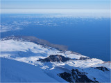
NE view from Gjuvtinden/2095m (again, our own GPS measurement).
You see the northernmost point of the Jan Mayen island.
On the point to the left (barely visible) lies the Hohenlohe crater/88m, which erupted in 1985, when the lava-flow ran northerly (left here) into the sea.
The flat snowbare area by the sea to the right of the Hohenlohe, is 5 km˛ new land created in the 1970 eruption, lasting from September 18th to medio October,
when 5 lava vents opened up along a 6 km long fissure at the NE base of the Beerenberg cone, and poured 500.000.000 mł low viscosity lava into the sea.
The fissure stretched SW from the shore up to approx. 600m above sea level, and a huge cloud of steam, smoke and ashes rose close to 15 km into the atmosphere.
The seawater in the area held 30şC (86şF) at the time, as opposed to its normal temperature of 0-3şC (32-37şF)!
The 1970 eruption was first observed by a Japanese airliner, who reported "A major forest fire on Jan Mayen!" :-D
The two glaciers reaching the sea in the foreground is the Friele glacier (farthest) and Prins Harald's glacier, both calving directly into the sea.
The black ridge between them is Knivegga (Knife edge), with Salsĺta/1108m as the highest point.
In the lower right corner you see a section of the ridge Himmelstigen (Sky ladder), stretching all the way from the sea to the Juvtinden summit.