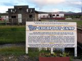
This sign from the days of the pipeline construction says: "Welcome to Coldfoot Camp. You are 55 miles north of the Arctic Circle on the east bank of the Middle Fork Koyukuk River at the mouth of Slate Creek, which drains to the east.
This is the site of the former gold mining community of Coldfoot, which was built here at the turn of the century. According to historical records, the original town of Coldfoot got its name in the Summer of 1900 when one of the waves of green stampeders got as far up the Koyukuk at this point, then got cold feet, turned around and ran. The settlement consisted of one gambling hall, two roadhouses, two stores, and seven saloons. In about 1920, the miners relocated in Wiseman, about 11 miles north of here.
Coldfoot, in the southern foothills of the Brooks Range, was a goldmining center in the early 1900's and served as a construction camp for the Alaska Pipeline in the 1970's. Today's Coldfoot evolved from a hamburger stand operating out of a bus. It offers basic motel lodging, 24 hour restaurant and bar, gas station, tire and vehicle repair shop, truckstop, 3.500-foot air strip, RV park, gift shop and laundromat for travelers on the Dalton Highway (mile 175).