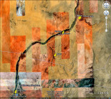
Khartoum to Meroe
Google of the Khartoum to Meroe road. You can see the Nile to the left, the grey “S” bend from Khartoum bottom left. This is a part of the Port Sudan highway. There are map pins at the sites of Naga , Meroe, our tented camp and the town of Shendi . The Pyramid field of Meroe is close to the Nile and the Port Sudan road at upper right. In sleepy Shendi today it is almost impossible to visualise thousands of infantry , cavalry, guns and river gunboats mustered here a hundred years ago for the British assault on Khartoum.