


|
|
|
|
|
|
| Todd Fischer | profile | all galleries >> Galleries >> Colorado Fall Trip 2025 | tree view | thumbnails | slideshow | map |

:: Best of Colorado Fall 2025 trip :: |
 6P5A4397 Crater near Capulin.jpg |
 6P5A4399 Looking south from Capulin.jpg |
 6P5A4409 Clouds over NE New Mexico.jpg |
 6P5A4449 Monument Lake.jpg |
 6P5A4458 Cucharas Pass colors.jpg |
 6P5A4473 Pronghorn chase.jpg |
 0T5A3556 Twin Lakes area.jpg |
 6P5A4484 Great Sand Dunes color.jpg |
 6P5A4490 Great Sand Dunes NP.jpg |
 6P5A4521 Hawk near GSDNP.jpg |
 6P5A4550 Twin Lakes.jpg |
 6P5A4556 Twin Lakes.jpg |
 6P5A4560 Twin Lakes North side.jpg |
 0T5A3565 Cottonwood Pass East side.jpg |
0T5A3574 Cottonwood Pass West side.jpg |
 6P5A4592 Cottonwood Pass West side.jpg |
 6P5A4600 Cottonwood Pass lighting.jpg |
Taylor Park Pano.jpg |
 6P5A4617 MC-130J in Gunnison.jpg |
 6P5A4701 MC-130J.jpg |
 6P5A4725 MC-130J in Gunnison.jpg |
 6P5A4759 MC-130J Gunnison.jpg |
 6P5A4769 MC-130J at Gunnison.jpg |
 6P5A4786 MC-130J in Gunnison.jpg |
 6P5A4819 MC-130J touchdown.jpg |
 0T5A3607 Along Ohio Creek Rd.jpg |
 0T5A3609 Along Ohio Creek Rd.jpg |
 0T5A3614 Along Ohio Creek Rd.jpg |
 20250926_082102 Headed up Ohio Creek Pass.jpg |
 0T5A3636 Ohio Creek Pass view.jpg |
 0T5A3638 The Castles in the distance.jpg |
 0T5A3672 East Beckwith on Kebler Pass.jpg |
 0T5A3677 East Beckwith Mtn Kebler Pass Rd.jpg |
 0T5A3708 The Raggeds in the distance.jpg |
 0T5A3730 Beaver Lake at Marble CO.jpg |
 0T5A3738 Near McClure Pass.jpg |
 20250926_080012 Ohio Creek Rd phone view.jpg |
 6P5A4967 Early morning Ohio Creek Rd.jpg |
 6P5A4976 Colors near the Castles.jpg |
 6P5A4983 Ohio Creek Rd view.jpg |
 6P5A4988 Along Ohio Creek Rd.jpg |
 6P5A4991 Cattle and The Castles.jpg |
 6P5A4996 Ohio Creek colors.jpg |
 6P5A5000 The Castles.jpg |
 6P5A5020 Ohio Creek deer.jpg |
 6P5A5045 Along Ohio Creek Rd.jpg |
 6P5A5064 Oh deer me.jpg |
 6P5A5086 Ohio Creek Rd.jpg |
 6P5A5098 The Castles.jpg |
 6P5A5103 Ohio Creek Rd.jpg |
 6P5A5147 Aspen trunks.jpg |
 6P5A5173 Solo trunk.jpg |
 6P5A5209 The Castles.jpg |
 6P5A5228 The Castles another view.jpg |
 6P5A5249 Kebler Pass Rd.jpg |
 6P5A5259 East Beckwith.jpg |
 6P5A5278 Lots of orange Aspens.jpg |
 6P5A5383 Near Marble.jpg |
 0T5A3747 Looking south across Morrow Point Res.jpg |
 20250926_142343 Storm south of Morrow Pt Reservoir.jpg |
 6P5A5504 Storm south of Cimmaron.jpg |
 6P5A5561 Along CO 92.jpg |
 6P5A5564 Headed down to Curecanti bend CO 92.jpg |
 0T5A3761 Burnt area Black Canyon of the Gunnison NP.jpg |
 0T5A3772 Black Canyon of the Gunnison National Park.jpg |
 0T5A3775 Black Canyon of the Gunnison National Park.jpg |
 0T5A3783 Black Canyon of the Gunnison National Park looking West.jpg |
 0T5A3786 Black Canyon of the Gunnison National Park burnt area.jpg |
 0T5A3791 Black Canyon of the Gunnison National Park destruction.jpg |
 0T5A3800 Black Canyon of the Gunnison National Park veining.jpg |
 6P5A5628 Black Canyon of the Gunnison NP.jpg |
 6P5A5636 Black Canyon of the Gunnison NP veining detail.jpg |
 6P5A5647 BCOTGNP visitor center overlook.jpg |
 0T5A3811 Headed up Grand Mesa.jpg |
 0T5A3814 Orange aspens on Grand Mesa.jpg |
 0T5A3832 Grand Mesa majesty.jpg |
 0T5A3844 Grand Mesa colors.jpg |
 0T5A3846 Grand Mesa hillside.jpg |
 0T5A3858 Glorious Grand Mesa hillside.jpg |
 6P5A5736 Grand Mesa view of Chalk Mtn.jpg |
 6P5A5749 Grand Mesa.jpg |
 6P5A5765 Motorcycle weather.jpg |
 6P5A5778 Tall trees.jpg |
 6P5A5795 Yellow leaves.jpg |
 6P5A5813 Aspen trunks.jpg |
 6P5A5821 Yellow on yellow.jpg |
 0T5A3868 Grand Junction rainbow.jpg |
 20250928_074818 Early morning rainbow over Colorado National Monument.jpg |
 20250928_075137 Double rainbow.jpg |
 6P5A5833 South of Grand Junction.jpg |
 6P5A5853 Rainbow over Grand Junction mesa.jpg |
 6P5A5868 Double Rainbow over Colorado National Monument.jpg |
 0T5A3871 Dallas Divide view.jpg |
 20250928_095427 Weather over Mt Sneffels.jpg |
 0T5A3881 Last Dollar Rd.jpg |
 6P5A5878 Mt Sneffels from Dallas Divide.jpg |
 6P5A5887 Sneffels Range moody weather.jpg |
 6P5A5893 Dallas Divide Sneffels Range.jpg |
 6P5A5898 Sneffels in the weather.jpg |
 20250929_115551 Mt Sneffels.jpg |
 6P5A5911 Near Dallas Divide.jpg |
 6P5A5913 Old homestead.jpg |
 6P5A5919 Wide range of colors.jpg |
 6P5A5938 Last Dollar Rd color variety.jpg |
 0T5A3883 Last Dollar Ranch entrance.jpg |
 20250928_101426 Last Dollar Ranch.jpg |
 6P5A5951 Elk on ridge LDR.jpg |
 6P5A5951 Elk on ridge LDR AND MOON v1.jpg |
 6P5A6002 Last Dollar Ranch elk.jpg |
 6P5A6007 Last Dollar Ranch elk.jpg |
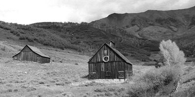 0T5A3907 Barns on Last Dollar Rd Telluride BW.jpg |
 0T5A3907 Barns on Last Dollar Rd Telluride.jpg |
 20250928_112806 Phone version of barns on LDR.jpg |
 0T5A3908 Last Dollar Rd above airport.jpg |
 0T5A3910 Last Dollar Rd Telluride.jpg |
 0T5A3911 Telluride storm.jpg |
 0T5A3920 Headed into Telluride.jpg |
 0T5A3944 CO 145 looking toward Telluride.jpg |
 20250928_114415 Storm across from Telluride airport.jpg |
 6P5A6092 Last Dollar Rd.jpg |
 6P5A6104 Keystone Overlook view.jpg |
 6P5A6114 Telluride area.jpg |
 6P5A6150 Gray weather in Telluride area.jpg |
 6P5A6159 Telluride area 2025 CO.jpg |
 6P5A6159 Telluride area.jpg |
 6P5A6234 Last Dollar Rd view north.jpg |
 6P5A6244 Little birdy.jpg |
 6P5A6258 Mountain rain.jpg |
 6P5A6264 Weather beyond the runway.jpg |
 6P5A6276 Raining in Telluride.jpg |
 6P5A6278 Telluride north side.jpg |
 6P5A6281 Telluride highlight.jpg |
 6P5A6295 Last Dollar Rd scenery.jpg |
 6P5A6334 N221NG landing at Telluride.jpg |
 6P5A6403 Telluride ski area.jpg |
 6P5A6404 Telluride lighting.jpg |
 6P5A6453 North side of Telluride area.jpg |
 6P5A6458 Telluride.jpg |
 6P5A6459 Telluride crazy lighting conditions.jpg |
 6P5A6471 Telluride north.jpg |
 6P5A6474 Telluride barns looking south.jpg |
 6P5A6476 On road into Telluride.jpg |
 6P5A6479 Black Bear Pass Rd.jpg |
 6P5A6491 Bridal Veil Power Station.jpg |
 6P5A6507 Telluride canyon magpie.jpg |
 6P5A6550 Telluride box canyon.jpg |
 6P5A6560 Telluride north side.jpg |
 6P5A6571 Telluride colors.jpg |
 6P5A6587 South of Telluride.jpg |
 6P5A6602 Sunlit hillside.jpg |
 6P5A6624 Ophir area CO 145.jpg |
 6P5A6643 CO 145 south of Ophir.jpg |
 6P5A6673 Sunlit patch east of Cortez.jpg |
 0T5A3968 Trout Lake.jpg |
 6P5A6680 Downburst east side of Durango.jpg |
 0T5A3995 Engineer Mountain.jpg |
 6P5A6697 Engineer Mtn outside Purgatory.jpg |
 6P5A6718 Engineer Mtn side view.jpg |
 6P5A6733 Patch of orange along MDH.jpg |
 6P5A6744 Million Dollar Highway plethora of colors.jpg |
 0T5A4012 Molas Overlook.jpg |
 20250929_091833 Phone view of Molas Overlook.jpg |
 6P5A6749 Molas Lake MDH view.jpg |
 20250929_093530 Phone sun thru the clouds.jpg |
 0T5A4022 Above Silverton.jpg |
 6P5A6758 Molas Overlook view.jpg |
 6P5A6762 Molas Lake view BW.jpg |
 6P5A6772 MDH Fog and colors in the valley.jpg |
 6P5A6781 Wide valley view.jpg |
 6P5A6788 MDH in the clouds.jpg |
 6P5A6789 Silverton below the clouds.jpg |
 6P5A6794 Durango and Silverton narrow gauge tracks.jpg |
 6P5A6797 Silverton area.jpg |
 6P5A6798 Low clouds or high town.jpg |
 6P5A6804 Floating peak MDH.jpg |
 0T5A4028 Yankee Girl Mine area MDH.jpg |
 0T5A4037 Clouds and colors.jpg |
 0T5A4045 South of Ironton.jpg |
 0T5A4046 Ironton area.jpg |
 0T5A4052 Ironton hillside.jpg |
 0T5A4056 Ironton area.jpg |
 0T5A4061 Crystal Lake MDH.jpg |
 0T5A4076 Ironton area.jpg |
 0T5A4084 Ironton area scenery.jpg |
 20250929_104057 US 550 MDH.jpg |
 20250929_105237 Crystal Lake reflection.jpg |
 20250929_130833 Ironton area.jpg |
 20250929_130904 Pilot.jpg |
 20250929_144846 Silverton from above.jpg |
 20250929_152334 US 550 near Lime Creek.jpg |
 6P5A6815 MDH Mtn views.jpg |
 6P5A6819 Along the MDH.jpg |
 6P5A6823 MDH US 550.jpg |
 6P5A6838 Yankee Girl Mine area.jpg |
 6P5A6851 MDH color.jpg |
 6P5A6899 Ironton area.jpg |
 6P5A6926 Ironton hillside.jpg |
 6P5A6952 Crystal Lake reflection.jpg |
 6P5A6956 Hillside by Crystal Lake.jpg |
 6P5A6983 MDH view.jpg |
 6P5A7001 US 550 Million Dollar Highway.jpg |
 6P5A7011 MDH mountains.jpg |
 6P5A7014 MDH dark clouds and hillside.jpg |
 6P5A7015 MDH what a road.jpg |
 6P5A7043 MDH color variations.jpg |
 6P5A7054 Aspen yellow profusion.jpg |
 6P5A7111 D and S 476 in Silverton.jpg |
 0T5A4115 D and S 476 about to leave.jpg |
 6P5A7058 MDH.jpg |
 6P5A7062 MDH Red Mountain.jpg |
 6P5A7086 MDH very red.jpg |
 6P5A7128 D and S pulling out of Silverton.jpg |
 6P5A7161 Durango and Silverton 476.jpg |
 6P5A7173 Shack no color this year.jpg |
 6P5A7188 MDH view.jpg |
 6P5A7227 Peak in clouds.jpg |
 20250930_085110 Wolf Creek Pass rain and fog.jpg |
 0T5A4146 Tunnel vision.jpg |
 6P5A7277 North of Southfork.jpg |
 20250930_101625 Gloomy day along the Rio Grande.jpg |
 20250930_102846 Farm lake along CO 149.jpg |
 6P5A7290 Shadows and light CO 149 .jpg |
 6P5A7306 Along CO 149.jpg |
 6P5A7348 One sunny spot CO 149.jpg |
 6P5A7350 CO 149.jpg |
 6P5A7352 Colors in burnt area.jpg |
 6P5A7362 Rio Oxbow Ranch.jpg |
 6P5A7370 Along CO 149.jpg |
 6P5A7394 Color in past destruction.jpg |
 6P5A7421 Ranch along CO 149.jpg |
 6P5A7453 Looking toward the Rio Grande headwaters.jpg |
 20250930_105953 North Clear Creek Falls.jpg |
 20250930_114247 Clouds and colors.jpg |
 6P5A7495 North Clear Creek Falls.jpg |
 6P5A7496 Area above North Clear Creek Falls.jpg |
 6P5A7499 North Clear Creek Falls.jpg |
 0T5A4177 North Clear Creek Falls.jpg |
 6P5A7462 North Clear Creek drainage area.jpg |
 20250930_104305 Weminuche Wilderness Vista.jpg |
 6P5A7532 CO 14 colors.jpg |
 6P5A7561 More shadows and light.jpg |
 6P5A7576 CO 149 beauty.jpg |
 0T5A4209 Headed to Slumgullion Pass.jpg |
 0T5A4216 Slumgullion looking towards Lake City.jpg |
 20250930_120609 Near Lake City.jpg |
 20250930_120800 CO 149 near Slumgullion slide.jpg |
 20250930_121120 Rain on Sunshine Peak.jpg |
 6P5A7639 Storm near Lake City.jpg |
 6P5A7641 Mountain rain.jpg |
 6P5A7647 Uncompahgre Peak and friends.jpg |
 6P5A7658 Lake City area scenery.jpg |
 6P5A7665 Lake City mountain weather.jpg |
 6P5A7667 A little spot of Sun.jpg |
 6P5A7682 Mountain weather.jpg |
 6P5A7700 Lake City area color and weather.jpg |
 6P5A7710 Uncompahgre Peak.jpg |
 6P5A7746 A panoply of lighting conditions.jpg |
 6P5A7786 Improving weather.jpg |
 6P5A7789 Slumgullion area CO 149.jpg |
 6P5A7807 Uncompahgre Peak.jpg |
 6P5A7822 Orangish profusion.jpg |
 6P5A7867 Lake City area color.jpg |
 6P5A7890 Sunny spot.jpg |
 6P5A7914 Headed toward Lake City.jpg |
 0T5A4229 Lake City area.jpg |
 20250930_141129 Clouds west of Gunnison.jpg |
 20250930_142636 On way to Blue Mesa Lake.jpg |
 20250930_142653 High desert area near Blue Mesa.jpg |
 20250930_143024 Blue Mesa Lake.jpg |
 6P5A8003 Headed to Blue Mesa Lake.jpg |
 0T5A4250 Almost at Blue Mesa Lake from LC.jpg |
 0T5A4263 Blue Mesa Lake and clouds.jpg |
 0T5A4268 Blue Mesa.jpg |
 0T5A4286 Rain headed to Monarch Pass.jpg |
 0T5A4276 Colorful cottonwoods along the Gunnison River.jpg |
 20250930_144807 Gunnison River phone version.jpg |
 0T5A4279 Pasture by the Gunnison.jpg |
 6P5A8040 Cottonwoods along Gunnison River.jpg |
 6P5A8057 Can you say WOW.jpg |
 6P5A8080 Osprey by the Gunnison River.jpg |
6P5A8085 Gunnison River osprey.jpg |
 6P5A8168 Buena Vista view.jpg |
 0T5A4307 East of Gunnison rain storm.jpg |
 20251001_065642 Buena Vista dawn.jpg |
 0T5A4327 Mt Elbert Twin Lakes.jpg |
 20251001_075446 Clouds over Elbert.jpg |
 20251001_080007 Twin Lakes reflections.jpg |
 20251001_131131 Red HIll Pass view.jpg |
 6P5A8188 Elbert clouds and sun.jpg |
 6P5A8193 Mt Elbert colors.jpg |
 6P5A8203 Twin Lakes reflections.jpg |
 6P5A8204 Twin Lakes.jpg |
 6P5A8250 Lone moose .jpg |
 6P5A8255 Headed up Independence Pass.jpg |
 6P5A8259 Independence Pass area view.jpg |
 20251001_083846 Top of Independence Pass.jpg |
 6P5A8264 Top of Independence Pass view.jpg |
 6P5A8282 Independence Pass 12095 ft.jpg |
 6P5A8284 Independence Pass.jpg |
 6P5A8286 Side mirror view Independence Pass.jpg |
 6P5A8288 Independence Pass east side.jpg |
 6P5A8350 Just outside Leadville.jpg |
 6P5A8353 Near Leadville.jpg |
 6P5A8371 Colorful Colorado.jpg |
 6P5A8377 Breckenridge ski area.jpg |
 6P5A8382 Boreas Pass Rd view.jpg |
 6P5A8403 Boreas Pass Rd Breckenridge.jpg |
 20251001_124614 Near Como.jpg |
 20251001_122934 Looking over Southpark.jpg |
 6P5A8426 Boreas Pass Rd view.jpg |
 6P5A8445 Lots of leaves.jpg |
Road from Como to Boreas Pass.jpg |
 0T5A4347 Near Como CO.jpg |
 6P5A8483 Isolated aspen patch from Boreas.jpg |
 6P5A8502 Looking toward Como.jpg |
 6P5A8582 Reg Hill Pass on US 285.jpg |
 6P5A8597 Fairplay area.jpg |
 6P5A8614 Sangre de Cristo Mtns near Villa Grove.jpg |
 20251001_143931 Sangre de Cristos view.jpg |
 6P5A8635 Ranch by the Sangre de Cristo.jpg |
 6P5A8665 Northern Harrier.jpg |
 6P5A8681 Geese near Alamosa.jpg |
 6P5A8694 Blanca Vista Park Alamosa.jpg |
 6P5A8696 Blanca Vista Park Alamosa.jpg |
 20251001_190445 Big sunset in Alamosa.jpg |
 6P5A8704 Alamosa moon.jpg |
 6P5A8709 Alpenglow.jpg |
6P5A8740 BNSF crossing over the Canadian River.jpg |
 6P5A8758 BNSF 6616 crossing the Canadian River.jpg |
| comment | share |