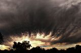
Thanks. Here's what amazes me about this. First, I was just driving home for lunch, and I glanced over to my left and saw this amazing sky forming out of nowhere. Those are obviously mammatus clouds. According to my field guide to weather, mammatus clouds form only in the presence of anvil clouds, but sometimes so far away that the anvil cloud cannot be seen (over 25 miles away). I don't have a clear picture of the total weather system, but I think that in this case there was no anvil cloud. Something, perhaps the remnants of the hurricane that was off the west coast, moved a whole lot of moisture into the mid or upper layers of the atmosphere, and they were subsequently blown east across Texas over a very dry layer.
I skipped lunch and climbed up on my roof to take pictures for about an hour as the system passed overhead. Another hour later, there was hardly a cloud in the sky.
It's one of the most amazing sky displays I've seen.
Maybe this crop is better. If I have time I need to redo it using the PSD pano instead of the jpeg pano. I can see some artifacts in the full-sized image. -- Victor
Yes, it is a pano. I think there were 23 images used in the pano (28mm is my widest lens). Taking these pictures from my roof is how I spent my lunch hour yesterday. :-) There is a possibility that there is more material that the pano software missed, but I don't think so. I took the largest rectangular crop that's parallel to the horizon. I could crop smaller, obviously, but I really wanted to keep the swoopy clouds on the upper, left, and I like how the pattern fanning out on the right balances the picture. I may try a tighter crop, but I think anything tighter would lose some of the impact. -- Victor
Wow!! Very cool sky. Nice catch, Victor. Is this a pano? If not, it seems you could expand it successfully/crop it differently, to make it more of a calendar sized ratio of w-to-h, no? -mikey