Lots of hiking this day in Acadia National Park. To see the trail hiked (and if you have Google Earth installed) right click and save this track file, then drag and drop onto Google Earth.
Here's a link to the high resolution version (about 8 meg).
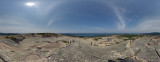
The field of view for the photographic pano is 360� and comprised from 108 individual shots taken on July 28, 2010 around 12:00 PM; focal length 10mm, fully manual, fixed WB, fixed focus, on Markins Q-Ball M10-L, two rows (no nadir nor zenith shot), portrait orientation, bracketed -2, 0, +2, processed HDR in PTGui (Equirectangular) with minor processing in PS CS4.
The setup shot to the right was shot with my Garmin 550 which I uploaded first so as PBase would snag the geo-coding first (click on view map link above), then I uploaded the 1000 pixel-wide version (above).
|
 |