


|
|
|
|
|
|
| Brooks Rownd | profile | all galleries >> Hawai'i >> Stranded In East Hawai'i >> May 20, 2010 - Mauna Loa Strip Road | tree view | thumbnails | slideshow |
Thursday morning brought rain, rain, rain. (Wednesday was bone dry, of course) In protest, I slept in. Eventually the rain looked endless and I decided to head to Mauna Loa Strip Road on the leeward side of Volcano, which is one of my destinations when there's little hope of a decent windward outing. Sure enough, after passing through Volcano Village it was very dry in Ka'u, and I spent the whole afternoon and evening squinting into the bright hot sun on Strip Road. Initially I thought I was going to zoom up to the top of Strip Road and look for the elusive exocarpos plants, but I after a few stops for bird counts I decided to do a complete set of point counts from Kipuka Ki up to the top of Strip Road instead.
Click Here To Read The Full Report, With Maps and Photos
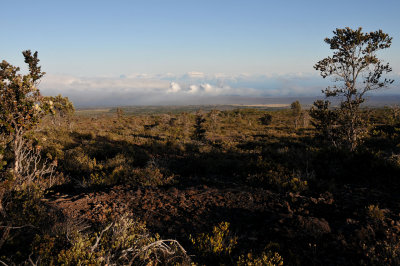
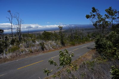
The point counts listed below go from the upper edge of Kipuka Puaulu at 4000 feet elevation to the goat fence above the end of Strip Road at 6900 feet elevation. I attached a map from a previous outing, showing the landscape from Kipuka Puaulu at the lower right, to just below the end of Strip Road at the upper left. Beyond the end of Strip Road is Mauna Loa Trail, crossing scrub forest and shrubland on lava fields. I stopped at various turn-outs along Strip Road which are not evenly spaced. Kipuka Puaulu and Kipuka Ki are a tall forest of koa and manele canopy, with more 'ohi'a in the upper half of Kipuka Ki. The 'ohi'a in Kipuka Ki were covered in bloom, but there were not as many 'apapane visiting them as I expected. You can see that Japanese white-eye counts were very high at lower elevations, and dwindled above. Northern Cardinal also dwindled at higher elevation. 'Elepaio, house finch and red-billed leiothrix were more evenly distributed. I was surprised that hwamei were present even up to 7000 feet elevation - I mostly see them in my backyard in Hilo, but seldom above 4000 feet in windward forests. Though the middle elevations above Kipuka Ki the forest is less diverse, with shorter koa and 'a'ali'i canopy growing on former cattle pastures, mixed with areas of shrubland and scrub forest on younger lava substrates. Nearer the end of strip road shrubland and thick scrub forests dominate, with scattered smaller stands of 20-30 foot koa, 'ohi'a, mamane and 'a'ali'i. I saw a single barn owl in the middle elevations, and a few gamebirds near the end of the road. At sunset I tossed some graham cracker crumbs to a kalij pheasant who boldly panhandled me as I removed my boots.
I got to the end of Strip Road with less than two hours of light left, and predictably I didn't find any exocarpos. However, I did have another interesting discovery. During one of the point counts, off the edge of the road I found a little outplanting of phyllostegia parviflora (and rubus macraei). This plant was thought extinct on Hawai'i for decades until it was rediscovered when the national park purchased the Kahuku Ranch unit (southwest rift zone of Mauna Loa) a few years ago. All of the outplanted phyllostegia parviflora seemed to have died young, except for one barely surviving plant.
Bird Counts: (Species Codes Here)
| station | time | APAP | IIWI | HAAM | OMAO | ELEP | JAWE | HOFI | YFCA | NOCA | RBLE | MELT | KAPH | CAQU | BAOW | Notes |
|---|---|---|---|---|---|---|---|---|---|---|---|---|---|---|---|---|
| 4050ft | 1209 | 9 | 1 | 1 | 2 | 8 | 2 | 1 | Kipuka Puaulu | |||||||
| 4250ft | 1230 | 3 | 1 | 8 | Kipuka Ki | |||||||||||
| 4280ft | 1246 | 6 | 2 | 1 | 12 | 2 | Kipuka Ki | |||||||||
| 4320ft | 1300 | 12 | 3 | 1 | 1 | 13 | 2 | 3 | 1 | Kipuka Ki | ||||||
| 4400ft | 1316 | 10 | 2 | 11 | 1 | Kipuka Cattleguard | ||||||||||
| 4500ft | 1330 | 3 | 1 | 1 | 6 | 1 | Fire Road | |||||||||
| 4500ft | 1340 | 4 | 1 | 3 | 10 | 1 | Koa-'a'ali'i | |||||||||
| 4600ft | 1353 | 5 | 2 | 2 | 10 | 1 | Koa-'a'ali'i | |||||||||
| 4700ft | 1404 | 3 | 1 | 7 | 2 | Koa-'a'ali'i | ||||||||||
| 4800ft | 1416 | 2 | 2 | 4 | 5 | Koa-'a'ali'i | ||||||||||
| 4900ft | 1431 | 6 | 3 | 1 | 3 | Powerline Rd | ||||||||||
| 4900ft | 1443 | 5 | 2 | 2 | 3 | 1 | 1 | Powerline Rd | ||||||||
| 5100ft | 1459 | 4 | 1 | 4 | 2 | 5 | 1 | Koa-'a'ali'i | ||||||||
| 5300ft | 1513 | 1 | 3 | 2 | 4 | 1 | 1 | Koa-'a'ali'i | ||||||||
| 5400ft | 1527 | 2 | 6 | 2 | 5 | 1 | 1 | Koa-'a'ali'i | ||||||||
| 5550ft | 1543 | 3 | 2 | 1 | Koa-'a'ali'i | |||||||||||
| 5750ft | 1600 | 2 | 4 | 2 | 4 | 1 | Koa-'a'ali'i | |||||||||
| 5900ft | 1611 | 3 | 4 | 4 | 2 | Koa-'a'ali'i | ||||||||||
| 6100ft | 1623 | 1 | 5 | 3 | scrubforest | |||||||||||
| 6200ft | 1638 | 2 | 2 | 1 | 1 | 1 | Koa-'a'ali'i | |||||||||
| 6350ft | 1707 | 1 | 1 | 2 | 1 | 3 | near | 2 | 4 | shrubland | ||||||
| 6700ft | 1725 | 1 | 1 | 2 | 1 | 1 | 2 | 1 | Top kipuka | |||||||
| 6750ft | 1755 | 2 | 2 | 1 | 1 | shrubland | ||||||||||
| 6800ft | 1817 | 2 | 3 | near | shrubland | |||||||||||
| 6700ft | 1845 | 3 | 3 | 1 | 1 | Top kipuka | ||||||||||
| station | time | APAP | IIWI | HAAM | OMAO | ELEP | JAWE | HOFI | YFCA | NOCA | RBLE | MELT | KAPH | CAQU | BAOW | Notes |
 Mauna Loa Strip |
 striproad_06mar10.gif |
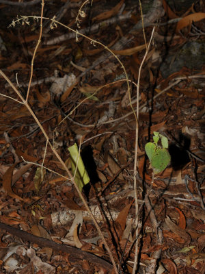 Phyllostegia Parviflora |
[ Mauna Loa Strip Road ] |