


|
|
|
|
|
|
| |
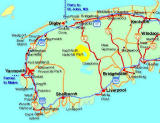
We caught the Cat Ferry over from Bar Harbor (speedy 2 hour trip but due to fog, couldn't see a whole lot). Landed in Yarmouth, exchanged some money, visited the Cape Forchu lighthouse, then headed along the Southern Shore ("Lighthouse Route") to Liverpool where we spent the night. Then we headed northwards towards Kejimkujik National Park where we had an interesting time viewing native petroglyphs before moving on to Digby (via Bear River) and finally on to Briar Island (last point on the little spit out from Digby). Stayed in a youth hostel there, did some hiking the next day and then headed towards Kentville and Waterville where we spent a night in a B&B. Next day, headed south again towards Mahone Bay, Lunenburg and the famous and scenic Peggy's Cove. Spent the night at a B&B in Peggy's Cove. (For a brief 16-photo Shockwave musical journey of our entire trip,click here, then come back to enjoy the rest of the photos. The musical photos show may take about 5 minutes to load).
All Images Represented here copyright protected. ALL RIGHTS RESERVED Mark Holmes 2001-2006