


|
|
|
|
|
|
| |
| 23-Jul-2017 | AKMC |
New Zealand is divided into 16 administrative districts, 9 on the North Island and 7 on the South Island. The largest in area (44,504 sq km) and second largest after Auckland in people (655,000) is Canterbury on the South Island. That region covers about 2/3 of the east coast, and runs west to the Southern Alps.
The capital, Christchurch (1,426 sq. km or 551 sq mi, 390K people) sits roughly in the centre of the east coast. The land surrounding it is the Canterbury Plains. Those plains were formed by the deposit of gravel from the Southern Alps to the west. They were deposited during glacial periods between 3 million to 10,000 years ago. As will be seen in some of the shots from our train trip to the west coast on Tuesday the 25th, this provided expansive, flat agricultural land.
Unfortunately there are also geological faults under the land which produce destructive earthquakes on occasion. Some of the worst of these occurred in 2010 and 2011, with the Christchurch earthquake of 22 February 2011 causing extensive damage to the city (much of it still visible when we visited 6 years later), and 185 deaths.
The fact that the land was formed by deposited gravel and soil rather than solid rock also makes the region vulnerable to extensive damage to utility systems (power, gas, water, sewerage) when these events occur.
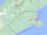
The red box that I've drawn here is a VERY approximate depiction of the Canterbury plains; if you believe Wikipedia they run to the south of Christchurch, however the town of Springfield, which we pass through on the TranzAlpine trip, is regarded as being one of the westernmost towns on the Plains and as you can see, it's to the northwest of Christchurch.
©2000-2024 AKMC. May not be used, copied or reproduced or used in AI training without written permission, especially by Facebook