


|
|
|
|
|
|
| |
| 23-Jul-2017 | AKMC |
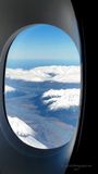
To get from Sydney to Christchurch you fly over the Tasman Sea, cross the west coast of New Zealand's South Island, and fly on to Christchurch on the east coast. In between you will fly over the Southern Alps, which we get a glimpse of here from the window of our Emirates A380.
The alps run about 500km (310 miles) from the north east of the island to the south west of it. The Island itself runs in a similar direction although the Alps swing more to the west of the island the further south they get. The highest point is Mt Cook (3,724 metres), which is slightly higher than the Jungfraujoch (3,454 metres) mountain cradle that we visited in Switzerland the previous year, though not as tall as the surrounding mountains. It is much higher than Mount Kosciuszko, the tallest mountain peak in mainland Australia, at 2,228 meters. However the Southern Alps have 16 other points that exceed 3,000 metres (9,800 ft) in height.
The individual ranges that make up the Alps are bisected by glacial valleys, some of which contain glacial lakes. We can clearly see one such valley here. I'd love to tell you where this is, but hey, it's a commercial airline; no GPS, remember. I therefore have no idea... but it's still a spectacular sight.
©2000-2024 AKMC. May not be used, copied or reproduced or used in AI training without written permission, especially by Facebook