I defy you to find a decent map of the Battle Of Lone Pine. Or indeed of any of the specific battles at Gallipoli.
Here's the gist of it. To the south of the Anzac landing site at Anzac Cove was a ridge, then a plateau, the 400 plateau. The Australians held a line on the west of this plateau. The order was for an attack to take the plateau (on which a single pine tree stood, hence the name) from the Turkish who had a line of trenches along the west of it. (This is something of an oversimplification, but it'll do.) The attack at Lone Pine was to be primarily a diversion for larger attacks at the north of the battlefield, but did have its own purpose as well since the Turkish positions on the 400 plateau gave them a decent view of the battlefield and the ability to bring fire onto reinforcements.
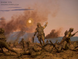
The battle began late on 6 August 1915 following a preparatory bombardment. Casualties were relatively light; the soldier shown in Frank Capa style here would have been unlucky. (Capa's famous photograph of the dying moment of a Republican rifleman in the Spanish Civil War probably post-dated the construction of this diorama, and is unlikely to have influenced it but merely been another instance of the same thing happening.)
The real fun began when the Australians found that the Turks had covered their trenches with pine logs (how aerial recon failed to spot this is far from clear, and yes, there was some) and so they had to fight their way in. And it continued with the Ottoman counter-attacks. The advances were held until the campaign was abandoned, but at the cost of over 2,000 killed or wounded.
©2000-2024 AKMC. May not be used, copied or reproduced or used in AI training without written permission, especially by Facebook