


|
|
|
|
|
|
| |
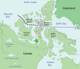
On the right side of the map, in blue, the voyage of the 1845 Franklin expedition is shown. Polar Bound was on the same course, but where Franklin went south toward King William Island, Cowper in Polar Bound sailed west, entering the McClure Strait and finally the Beaufort Sea. The black dots trace his route. In Franklin's time that route was solid ice.
All photos are the exclusive property of James Mason
| comment | |