Our interest in Battle Creek goes back a ways. By looking at the topo map, one can see that the creek drops 200-300' in elevation in a short distance before it meets Yonah Lake. Now all it would take is someone with the time and desire to find a good way in to check it out. Of course, Bernie is the right man for this job. He made several recon trips to the area plotting a route, then brought JC and I in for a look. I wasn't taking notes, so Bernie also did a write up with directions. This hike is for experienced adventure seekers only! If you get lost in here, no one will ever find you - ever. It's also gamelands, so wear blaze orange during hunting season. We came across 3 hunters on today's trip. Here are the directions -
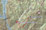
Take Damascus Church road from Long Creek Road (US 76) like you were going to Opossum Falls. Just keep going past where you park for Sid's Falls. When you come to Bull Sluice Road, do not turn; go straight. In 0.5 miles, the pavement ends and the road becomes FS 753. In about 2.0 miles, look for FS 753 A on the right. Go about 0.55 miles to the end of the road and park. The trail begins straight ahead. Follow the old logging road through a tunnel of young pines, around a ridge and down to a gap (It's really a filled-in gulley). Straight ahead, the logging road begins to climb to the top of a ridge. Go right when you intersect another road. Follow it on-grade for several minutes as a low ridge rises on the right and then slowly falls. It is a little tricky to find the next part of the trail. Before you reach the end of that ridge; after crossing a downed tree and before you come to more tree tops across the trail, strike out toward the top of that ridge on the right. (You could go all the way to the end where a very old logging road comes in from the right and follow that road back to the right). There is an ATV trail on the crest of the ridge that leads down to an intersection with a logging road. Go right at that road and right again in a few yards. The trail follows a flat ridge until it turns right to get around some brush and begins a descent around the ridge. You will pass three metal fence posts marking boundry lines along the way. The trail now follows a ridge down for about five minutes and sort of ends. The ATV trail continues down to the right. Stay straight on the ridge and bushwhack on down to the gap. You should see a marker there, as well. Go past the that gap to the top of a small knoll. Turn left and work straight down the secondary ridge on the east side of the waterfall.