We continued on with the directions I had received from Luke. About 4 miles up Cullowhee Mtn Rd from the fork, turn right just before the red house on the right. This is a narrower gravel road that looks like a driveway. This road curves up to the right. In .4 miles, park at the abandoned church on the right. Walk down to the road on the right a short ways past the church, then take it a short distance past the gate along Dodgen Creek to where the creek crosses the road. A faint trail goes down the right side of the creek a short distance to the top of the first waterfall. I was expecting this road to be a forest road, but the gate was new and there was equipment parked and spools of fiber optic cable being run.
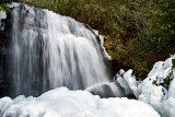
Ice obscured the bottom part of the waterfall which was a nice surprise, but I'm not sure if it was covering rocks or debris. The falls is about 20' high.