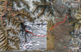
Deosai Plains lie in the south of Skardu town and in the east of Astore valley. This map shows some important places in and around the Deosai Plains. The red line roughly marks the jeep trail (it's just an estimate, I don't remember the path we followed and we did not have a GPS, so this line is probably inaccurate, but it serves to give an idea of the path).
Download this collection of 700+ Northern Pakistan placemarks (Google Earth file). This collection marks many towns, rivers, glaciers, peaks, passes and base camps in Northern Areas and NWFP.