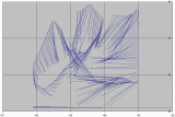
This image is created using hurricane hunter data
for tropical storm Erika. The lines all point in
a direction perpendicular to the wind direction.
If facing downwind, they point to the left. The
result is that they point to the center of circulation
of the storm -- at least a local COC.
The length of each line is proportional to the
strength of the wind. The stronger the wind, the
longer the line. I hope this creates a sense of
where the true center of the storm is. Rather than
just looking at the small center, this imagery
allows one to visualize the entire storm at once.
One should be cognizant when viewing the image
that it takes some time for the hurricane hunter
to traverse the storm. It is not a snapshot like
a satellite photo of the same storm would be.
Scale at the bottom is 10, 20, 40, 80 knots.