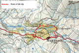
This little circular route takes you across the valley to Dzong (Jzong) and back to Raunipawa via Jharkot. This route used to be out of bounds as it took you into Upper Mustang. It is now open to trekkers and is well worth the effort. Apart from the villages, you get good views of the Thorong la and of Tilico, Nilgiri and Dhaulagiri. You could combine it with a visit to the Muktinath temples. Head back along the track towards the Temples and just before you go through the arch take the trail on the left. You have to cross a suspension bridge to reach Chengar and after passing through the village you walk down the valley to Dzong. You can see the remains of a fort and the gompa sitting above the village as you head down the valley. You can then head back across the valley to Jharkot and back to your lodge in Raunipawa or I believe it's possible to follow a trail on the north side of the valley that takes you down to Kagbeni. Jharkot is being spoilt by the construction of a massive, community centre right in the middle of the village. It dominates the whole skyline of the village that used to be so attractive.