


|
|
|
|
|
|
| |
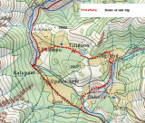
This is the Titi Lake side trip. Head north out of Kalopani and cross the suspension bridge to the east bank of the Kali Gandaki. After about 30 minutes take the right hand path uphill climbing steadily until you reach a track (road) coming from the left. This is the new road replacing the footpath and was build to facilitate timber harvesting. You can now follow this all the way to Titi village and Lake. Stop and look back frequently as you will have great views of Dhaulagiri and the icefall. After the lake you will reach a group of stone chortens and the path then divides. Either route will take you to the village of Taglung. Leave the lower part of Taglung by the track which heads south-west, down to and along the side of the Pangbu Khola. After passing through Chhoya village, cross the Kali Gandaki on the suspension bridge, turn left and head down to the road and on towards Ghasa.
Copyright © 2000 - 2018; "thesilvertops" All rights reserved.