


|
|
|
|
|
|
| |
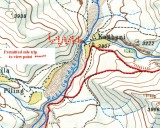
This approximate map shows the relatively new track that has been built above Kagbeni. Cross the Kali Gandaki river by the bridge behind the Gompa and follow the zig-zag trail climbing steeply up the hill. The trail ends in a viewpoint high up on the ridge. I believe it's about a one thousand metre climb. In the right conditions and at the right time of day, you are rewarded for your efforts by views northwards along the Kali Gandaki into Upper Mustang and to the south and east, the Annapurnas are spread before you. The nearest peaks will be Tilico on the left and Nilgiri on the right (but left of the Kali Gandaki) with Annapurna 1 and other peaks between them. You may also see Dhaulagiri and Tukuche on the right of the Kali Gandaki. I haven't done this hike but eagerly await someone's photographs of the views.
Copyright © 2000 - 2018; "thesilvertops" All rights reserved.