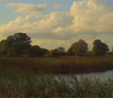
Between the two large trees to the rhs of this image,can be seen a mound;this is the depleted remains of a Norman motte,called Castle Toll.Excavation has shown it had two phases of occupation in the C.13th. century.Between the orangey coloured tree(mid-image) and the motte,to the right,can be seen an elevated piece of land,this was the bailey,to the motte.
Across the image,from left to right,along the tree line,marks the seaward edge of the Saxon burh of Eorpeburnan,so many historians/archaeologists believe.The burh is mentioned in the Burghal Hideage.It was attacked by the Danes in 892AD.Excavation has shown the site was unfinished
see http://www.castlefacts.info
see http://www.fortifiedengland.com/Home/Categories/ViewItem/tabid/61/Default.aspx?IID=2764
see http://www.pastscape.org.uk/hob.aspx?hob_id=417477