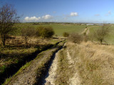
What doesn't come across here,is that in the preceding weeks,it had rained and rained.And,as anyone familiar with walking on chalk will tell you,the top inch or so quickly turns to slurry.Well,in shot all the ruts were slurry and all adjacent ground,although green to the eye,were covered in a fine layer of,...slurry..,from other poor souls who'd also tried to avoid the worst bits.On top of that,the path/track/rut city,wasn't the one shown on the map.Rather,it had been amalgamated with another path,some distance to the east,to avoid walkers going through a field.This meant that when I came to a left turn,that I should have taken,I went straight on,because the turn wasn't on the map.I kept going about 1/2 mile through a thicket,breaking branches overgrowing"my path" only to arrive at a gate,with a large NO ENTRY sign on it.So,returning to this image,the path should have led from the ruts in the foreground,straight ahead,to the white building in the middle distance.