


|
|
|
|
|
|
| |
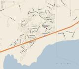
Note that the areas that are near the interstate on the north side and all of the areas south of the the interstate were inundated by the storm surge. This map doesn't detail where the Jourdan River (which flows to the Bay) is situated, on the western side of Diamondhead, where many homes were flooded.
images © J. Steven Martin - for usage or purchase info., click here.
| comment | |