


|
|
|
|
|
|
| |
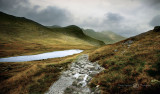
Taken from the flanks of The Pike o' Blisco.
The walk started from The Three Shires Stone on a rather dull and rainy day.
After map references and compass settings were made, My wife and I set off for The Crinkles.
As we climbed higher heading for Crinkle Crags the weather became worse
with heavy mist. At one point on Crinkle 1 the visibility was down to just a few yards
so it was time to stop and take a break. We could hear voices of other fell walkers nearby
but could not see them.
After a short while the mist eased off so we continued our climb along the ridges.
After a wrong turn near the last Crinkle (also made by 4 other groups of walkers) we finally made the ascent of Bowfell.
At the summit of Bowfell the weather turned foul and all landmarks were obliterated.
This gave us an uneasy feel as we started our descent to head back to our starting point.
Because we had made a wrong turn earlier we were soon treading ground we didn't recognise and the
pathway faded to nothing (often the case on some approaches to mountains in the Lake District)
We stopped while I took a compass bearing, however the surrounding rocky ground made the compass needle spin a 360 and would not settle.
Eventually I managed to find a grassy area where the needle settled and took a bearing and map reference - we were still on course according to my reckoning
however, my compass indicated we were exactly 180 degs out, thus heading away from our destination!
I knew that we had definitely not walked in a circle so confusion was starting to set in!
I laid the map on the ground, flicked away the pellets of sheep shit that was rolling
all over it and did further compass readings and map positioning aligned to the bearing reading from the start of the walk. However, due to the dense mist I could not triangulate our exact position
using other landmarks.
At that moment a young female fell runner approached through the mist like an angel from the clouds and came over to us.
We explained our plight of the spinning compass and loss of path in the mist, so, to help confirm
our positioning, she took out her map and compass to compare notes and readings.
Further confusion set in when the girl reckoned we were near to the base of Bowfell and I knew by time referencing we had walked well over 1.5km 'away' from it so should 'not' be too near to it.
After much deliberation the mist was now at it's worst, only a few hours of daylight remained so we had to get off the mountain and fast.
I marked the grassy earth where we stood and stayed still while the fell runner looked around to try and retrace the path she had come up. Luckily she found it, a narrow bit of path barely visible in the mist , so we decided to try that and see where we ended up.
The three of us carefully felt our away along the rocks and along the path.
As we descended I began to recognise a particular wall of rock where earlier in the day I remember stopping to chat to a group of charity walkers. A little further along, the path became more evident and a few landmarks began to appear through the now receding mist.
Yes! At last we were now relieved to be back on a confirmed 'known' location of mountain
and continued to our base camp where I made us all a welcoming cup of fresh hot tea and a bite to eat!
I was pleased that although my compass was telling me different, I knew we had not walked in a circle and 'had' to be where we thought we were, and this later proved to be correct!
I calculated that we had met the young runner at Crinkle 1 - the last main crag on our return before the main footpath appears and that the girl was about 1.2 km off her intended course.
So, it was a good job we all met when we did!
Since this quite unnerving situation I bought a GPS Navigation aid to accompany my maps and compass
and always carry these items with me wherever and whatever the weather.
They have since proved there worth and value on similar adventures and situations up on the mountains!
The mountains are a fantastic place to be, but NEVER underestimate them as conditions can change within seconds and you will become disorientated rapidly.
Be PREPARED for the worst and you will do well.
Let this be a lesson to all adventure walkers alike!
Steve Highfield
All Images Copyrighted - Steve Highfield Galleries© 2009. Images Must Not Be Used Without My Written Permission
Please login or register.