photo sharing and upload picture albums photo forums search pictures popular photos photography help login
LeSon Photography | profile | all galleries >> Visit ....The Great Southwest: Utah, Arizona, Colorado >> Visit ...Three Arches at Natural Bridges National Monument tree view | thumbnails | slideshow

Visit ...Three Arches at Natural Bridges National Monument

+

Day 05 of 07. August 19, 2009

We got the bridge info from the Commerce center during our Capital Reef stay next to the hotel. We were on the move to our last stay location, on the way to Monticello on the east side of Utah, border of Colorado. Monticello had its midpoint of Mesa Verde at the southwest, and Arches NP at the north of the town.

The 3 bridges were located on Hwy 95 at junction of 261, on the southeast corner of Utah.

_______From National Park Visitor center_____

Natural Bridges sits high on Cedar Mesa, 6,500 ft above sea level. Intermittent Streams have cut two deep canyons and three massive bridges in sandstone formed from what was once the shore of an ancient sea. At each of the bridges, trail descends into canyons from the loop road. A longer trail meanders along the canyon bottoms through oak and cottonwood groves, connecting the three bridges in one loop hike. From the paved road surface, the loop Bridge View Drive is 9 miles (14.5km) from the Visitor Center.

Two of the bridge can be seen from the road. Sipagu, 0.6 M, Kachina, 0.7 M; yet the drop in elevation can be very challenging to reach them. We chose to take a short hike to Owachomo Bridge, 0.2 M from the main road.

___Sipagu Bridge____
From the Visitor Office

Is the second largest natural bridge in the world. Only the Rainbow bridge in Glen Canyon is the One biggest in the world. In Hopi mythology, a “sipagu” ia a gateway through which souls may pass to the spirit world. The trail to the canyon bottom is the steepest in the park. A stair case and 3 wooden ladders aid in the descent. At the top of the stairway, notice the logs reaching from the cliff wall to the larger fir on the larger fir of the stairs. Early visitors to the park climbed down this tree to reach the canyon. At the base of the tree you can see the remains of the earlier staircase. The remaining portion of the trail leads down to a series of switchbacks and ladders to the grove of Gamble’s oak beneath Sipapu.

___Kachima Bridge___
From the Visitor Office

Kachina is massive bridge and is considered the “youngest” of the three because of its span. The relatively small size of its opening and its orientation make it difficulty to see from the overlook. The pile of boulders under the far side of the bridge resulted from a rock fall in 1992, when a approximately 4,000 tons of rocks broke off the bridge. As you descend the switchbacks, notice the “Knickpoint” pour-off in Armstrong Canyon below to your left. During the floods this spout sends a muddy of red waterfall plunging into the pool below. The bridge is named for the Kachina dancers that play a central role in Hopi religious tradition.

____Owachomo Bridge____
From the Visitor Office

Owachomo means “rock mount” in Hopi, and named after the rock formation on top of the southeast end of the bridge. From the overlook, the twin buttes called the “the Bear’s Ears” to break the eastern horizon. The original road to the Natural Bridges passed between these buttes, ending across the canyon from Owachomo Bridge at the original center (which was a platform tent). The old trail still winds up the other of the canyon, but seldom used. Notice that Tuwa Creek no longer flows under Owachomo like it did for thousands of years. The bridges’ delicate form suggest that it is has eroded more quickly than the other bridges.

We took a short hike to the bridge from the parking lot, a 0.2 mile distance. The elevation drop was not challenging, most people could reach the location without difficulty.


Return to the southwest
https://pbase.com/shaunwin/southwest

+ +
Visit ...Three Arches at Natural Bridges National Monument
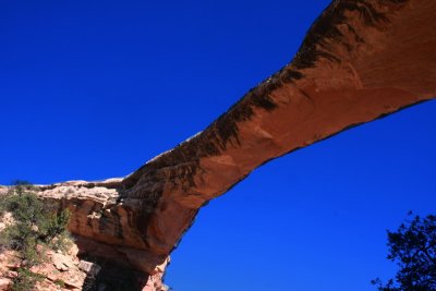
:: Visit ...Three Arches at Natural Bridges National Monument 
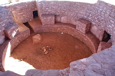
::
Visit ... The Anasazis Indian Ruins  of  the Peublos
:: Visit ... The Anasazis Indian Ruins of the Peublos ::
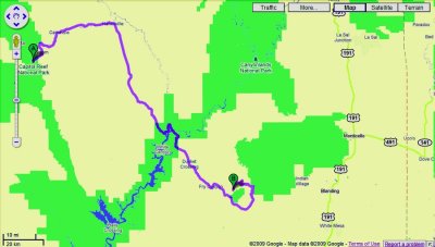
Capital Reef to Natural Bridges, 150M drive ...>