


|
|
|
|
|
|
| |
| 14-Feb-2009 | |
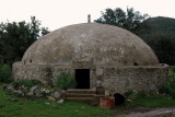
Kazderesi'nden Girel'e doğru kuzeye giden orman yolunun sonunda
37°05'01"N , 27°21'54"E
kitabe
(iki mahallenin sınırında olduğu için, aynı foto Gölköy albümünde de var)
| Full EXIF Info | |
| Date/Time | 14-Feb-2009 12:26:25 |
| Make | Nikon |
| Model | NIKON D70 |
| Flash Used | No |
| Focal Length | 31 mm |
| Exposure Time | 1/250 sec |
| Aperture | f/8 |
| ISO Equivalent | 200 |
| Exposure Bias | 0.00 |
| White Balance | 0 |
| Metering Mode | matrix (5) |
| JPEG Quality | |
| Exposure Program | 0 |
| Focus Distance | 3.162 m |
© Sabahattin Bilsel. All rights reserved.
| comment |