photo sharing and upload picture albums photo forums search pictures popular photos photography help login
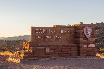
Richard Glenn | profile | all galleries >> The American Southwest >> Capitol Reef National Park, Utah 2015 tree view | thumbnails | slideshow

Capitol Reef National Park, Utah 2015

Capitol Reef National Park is a United States National Park, in south-central Utah. It is 100 miles (160 km) long but fairly narrow. The park, established in 1971, preserves 241,904 acres (377.98 sq mi; 97,895.08 ha; 978.95 km2) and is open all year, although May through September are the most popular months.

Called "Wayne Wonderland" in the 1920s by local boosters Ephraim P. Pectol and Joseph S. Hickman, Capitol Reef National Park protects colorful canyons, ridges, buttes, and monoliths. About 75 mi (121 km) of the long up-thrust called the Waterpocket Fold, a rugged spine extending from Thousand Lake Mountain to Lake Powell, is preserved within the park. "Capitol Reef" is the name of an especially rugged and spectacular segment of the Waterpocket Fold near the Fremont River. The area was named for a line of white domes and cliffs of Navajo Sandstone, each of which looks somewhat like the United States Capitol building, that run from the Fremont River to Pleasant Creek on the Waterpocket Fold. The local word reef refers to any rocky barrier to travel. Easy road access only came in 1962, with the construction of State Route 24 through the Fremont River Canyon.
IMG_2797.jpg
IMG_2797.jpg
IMG_2795.jpg
IMG_2795.jpg
IMG_2796.jpg
IMG_2796.jpg
IMG_2794.jpg
IMG_2794.jpg
IMG_2798.jpg
IMG_2798.jpg
IMG_2799.jpg
IMG_2799.jpg
IMG_2800.jpg
IMG_2800.jpg
IMG_2803.jpg
IMG_2803.jpg
IMG_2804.jpg
IMG_2804.jpg
IMG_2806.jpg
IMG_2806.jpg
IMG_2810.jpg
IMG_2810.jpg
IMG_2811.jpg
IMG_2811.jpg
IMG_2812.jpg
IMG_2812.jpg
IMG_2813.jpg
IMG_2813.jpg
IMG_2814.jpg
IMG_2814.jpg
IMG_2817.jpg
IMG_2817.jpg
IMG_2820.jpg
IMG_2820.jpg
IMG_2826.jpg
IMG_2826.jpg
IMG_2828.jpg
IMG_2828.jpg