I just got back from Taro. I agree with the estimate that 80% of the town was destroyed. It was basically wiped off the map. Only the homes and schools that were on the hillside survived. The waves come right over this wall and decimated Taro and the destruction was mind bending. I want to return this winter to help take supplies over because I fear winter will be dangerous for the elderly trapped in their homes. Since this was the fourth time it was hit with a tsunami I think the rebuilding should only be on the hillside. The harbor and surface topography is just too dangerous to rebuild.
From what I've seen in recent land and aerial photos, and read on Japanese news sites, it seems almost all of the breakwaters were heavily damaged along the coast.
Taro is north of Miyako, here is the google map of its location:
If you go south down highway 45 from Taro, you get to Miyako.
One estimate I read today on a Japanese site suggested 80% of the buildings in Taro were destroyed, either by the earthquake, tsunami or fire. The death & missing appears to be lower than other towns along the coast.
Ray Brown
23-Mar-2011 02:09
WHERE EXACTLY IS TARO TOWN? I GET THE IDEA IT IS NORTH OF MIYAKO. ALSO, IT LOOKS LIKE THE OUTER BREAKWATER OF OFUNATO HAS BEEN DEMOLISEHED.
I've been searching Japanese sites since the day of the tsunami for information on Taro town. Initially there was mixed information about Taro and the success of the wall, now looks very bad and the town was probably as badly hit as the rest of the coast. I hope the wall helped to save townsfolk by giving them a few more minutes to get to safety. It seems at least 75% made it to higher ground and survived.
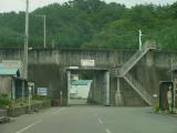
The harbour and ocean where behind me and on the other side of the Tsunami wall was the village. In case of an earthquake (possibly also underwater volcano), the alarm is sounded for a tsunami warning, the harbour evacuated and the entrance is closed.
This structure won't stop all tsunami from destroying this particular village, as there was a tsunami in the 1950s (1954?) I think that was a bit higher than this structure, but in general, it will stop 99% of tsunamis affecting this village. These structures are quite common in Japanese fishing villages. This wall was in Tohoku region, which is the on the main Japanese island of Honshu and is a few hundred km north of Tokyo.
Hi Richard,
What does the Tsunami Wall Entrace mean. Does this mean that they have a complete wall to protect against thes giant waves. If so this must be a great structure to visit.