


|
|
|
|
|
|
| RJB Graphics | profile | all galleries >> Me, My and Myself >> The Western Tour 2009-2011 | tree view | thumbnails | slideshow | map |
An urge to go west "young man".. Alberta and British Columbia: Mountains and Waterfalls
Currently more or less in random order, but am working to place in chronologic sequence and finish filling out the portfolio.
Start viewing the picture in the "large" format. If the picture is a panorama and much wider than high, there should be an instruction to click on the "original size". That will give better viewing. At times there are variants of the picture, usually to a high contrast Black & White ala Ansell Adams.
Please comment on the pictures (like or hate).
| previous page | pages 1 2 3 4 5 6 7 8 9 10 11 12 ALL | next page |
 Hawkins Middle copy.jpg |
 bx01 copy.jpg |
 1E6V6724.jpg |
 BX_combined copy.jpg |
||||
 Bear Falls.jpg |
 Bear falls view.jpg |
 Bebdie Falls copy.jpg |
 Binding_Web.jpg |
||||
 Bow_river copy.jpg |
 Brandywine01 copy.jpg |
 Brandywine_Panorama1 copy.jpg |
 Bridal_HDR2.jpg |
||||
 Bridal_green01 copy.jpg |
 Bridal_green02 copy.jpg |
 Bridal_green03 copy.jpg |
 Bridal_veil copy.jpg |
||||
 Castle Mtn copy.jpg |
 Cottonwood Falls copy.jpg |
 Crazy Falls copy.jpg |
 Crow+close copy.jpg |
||||
 Crowfoot Glacier copy.jpg |
 Crowfoot_Lake copy.jpg |
 Crystal_Clear.jpg |
 Edith_alpine flowers 01.jpg |
||||
 Evening sun_ copy.jpg |
 Extra_JC_mid copy.jpg |
 Fintry_Panorama2 copy.jpg |
 Fisherman's_downstream copy.jpg |
||||
 Fletcher_Panorama3 copy.jpg |
 Fletcher_Panorama6 copy.jpg |
 Gardiner Falls copy.jpg |
 Hanging Moss.jpg |
||||
 Hardy01 copy.jpg |
 Hardy02 copy.jpg |
 Hardy03 copy.jpg |
 Hawkins 1 of 3 copy.jpg |
||||
 Hawkins Lower copy.jpg |
 Hawkins Lower.jpg |
 Hawkins_Painter copy.jpg |
 Helmcken copy.jpg |
||||
 IMG_7202 copy.jpg |
 IMG_7433 copy.jpg |
 IMG_7439 copy.jpg |
 IMG_BX_7498.+.5 copy |
||||
 JC_Falls_? copy.jpg |
 JC_Upper copy.jpg |
 JC_mid_catwlk copy.jpg |
 Lower Close JC Final Panor copy.jpg |
||||
 Lower JC 02 copy.jpg |
 Lower JC Close 02 copy.jpg | Upper Half of Lower Falls, Johnson Canyon |  Lower Spencer copy.jpg |
 Lyle_ Reflections copy.jpg |
|||
 Lyle_Panorama1 copy.jpg |
 Lynn 02 copy.jpg |
 Maligne_canyon.02 copy |
 Maligne_canyon_HDR2.jpg |
||||
 Meachan Falls copy.jpg |
 Mid JC 02 copy.jpg |
 Mid JC copy.jpg |
 Mid_JC copy.jpg |
||||
 Mid_catwalk_JC copy.jpg |
 Mistaya 2010 Flow copy.jpg |
 Mountain Stream copy.jpg |
 Mt Clavell.02.B&W.jpg |
||||
 MtEdithCavell_panorama.02.jpg |
 MtnStream.jpg |
 Namarata Falls_Blossoms .jpg |
 Namarata copy.jpg |
||||
 Okanogan_Yellow 02 copy.jpg |
 Okanogan_Yellow copy.jpg |
 Okanogan_Yellow.jpg |
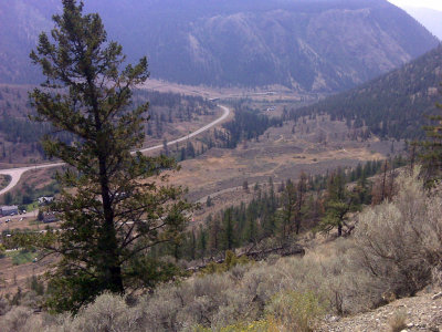
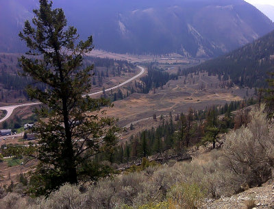 Pavilion.jpg |
||||
 ST copy.jpg |
 Shannon_Panorama2 copy.jpg |
 Skunk Creek.jpg |
 St. Mary's Lake 01 copy |
||||
 St. Mary's Lake 02 copy |
 Sunwapta.02 copy |
 Sunwapta05.jpg |
 Sunwapta_falls 02.jpg |
||||
 Tulip Creek Downstream 02 copy.jpg |
 Tulip Creek Downstream copy.jpg |
 Tulip_Mossy_Walls copy.jpg |
 Tulip_Mossy_Walls.DB copy |
||||
 Tulip_texture copy.jpg |
 Tulip_texture.DB copy |
 Two_means_transport_ copy.jpg |
 Uplands.jpg |
||||
 Upstream_MacD copy.jpg |
 Verdant_Growth copy.jpg |
 bear copy.jpg |
 bear02 copy.jpg |
||||
 bear03 copy.jpg |
 bear04 copy.jpg |
 bear_flowers copy.jpg |
 bebdie_Panorama1 copy.jpg |
||||
 bebdie_Panorama2 copy.jpg |
 big horn sheep 02.jpg |
 bx02 copy.jpg |
 bx03 copy.jpg |
||||
 bx04 copy.jpg |
 cascade copy.jpg |
 chase_Panorama1 copy.jpg |
 chasefalls copy.jpg |
||||
 christina_port copy.jpg |
 clavell_glacier_runoff.jpg |
 clavell_turbulence.jpg |
 crazy_Panorama1.jpg |
||||
 crazy_Panorama2 copy.jpg |
 crazy_Panorama3 copy.jpg |
 crowfoot.02 copy |
 douglas falls.jpg |
||||
 fintry copy.jpg |
 fisherman02 copy.jpg |
 fisherman_path copy.jpg |
 fishermans02 copy.jpg |
||||
 fletcher01 copy.jpg |
 fletcher_4 copy.jpg |
 lacdesroches.db.jpg |
 lush_undegrowth_bridal copy.jpg |
||||
 lyle_reflection copy.jpg |
 maligne_canyon.01 copy |
 marysville05 copy.jpg |
 mist_canyon copy.jpg |
||||
 mist_deep copy.jpg |
 mistaya combined copy.jpg |
 mistaya09 copy.jpg |
 reflections copy.jpg |
||||
 shannon01 copy.jpg |
 shannon02 copy.jpg |
 shannon_Panorama3.jpg |
 shannon_Panorama4 copy.jpg |
||||
 south cariboo lake.jpg |
 spencer01 copy.jpg |
 spencer01.jpg |
 spencer02 copy.jpg |
||||
 spencer02.jpg |
 spencer_Panorama1.jpg |
 spencer_far copy.jpg |
 spencer_far.jpg |
||||
 varied_alpine.jpg |
 2009 Western Tour | For about a week I wandered through the Rocky Mountains in Alberta and British Columbia. What I learned from this is that going on a set time frame does not allow for more spontaneous photography but rather limits the extent of the images. | Castle Mountain to Mount Ishbel Panorama | The first of the panoramas I photographed in the journey through the mountains. Castle mountain on the left Through to Mt. Ishbel on the right. Eisenhower Peak is the right most peak making up Castle Mountain. The Bow river is in the foreground. Best viewed on Original Size |
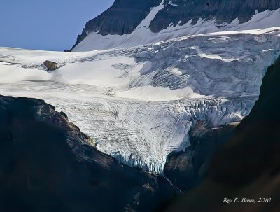
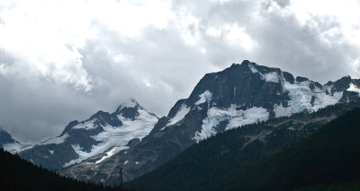
 Crowfoot Glacier | One of the first glaciers seen from the Icefiel Parkway within Banff National Park Taken 3.39 Km from Crowfoot Glacier, looking over Bow Lake Best viewed on Original Size |
|
 Crowfoot Glacier | Best viewed on Original Size |
 Crowfoot Glacier | Best viewed on Original Size |
 Crowfoot Glacier | Best viewed on Original Size |
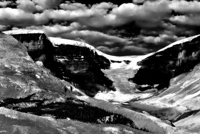
 Crowfoot Glacier (B&W) | Best viewed on Original Size |
 Crowfoot HDR | Best viewed on Original Size |
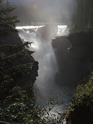
 Before Athabasca | Looking southerly to Cirrus Mountain (5.5 to 7Km). From a severe switchback. Best viewed on Original Size |
 Mt. Athabasca to Mt. Kitchener 0604hrs Panorama | Mt. Athabasca (far left) 4.3 Km , Mt. Andromeda (Left of centre) 4.9 Km, Athabasca Glacier (Center) 1.13 Km, (top of Glacier 7.1 Km), Un-named Mountain (Right of centre) Dome Glacier 2.5 Km and Mt. Kitchener 5.5 Km (Far Right). From Mt. Athabasca to Mt Kitchener 8.3 Km Best viewed on Original Size |
Mt. Athabasca to Mt. Kitchener (0752hrs) | A slightly later in morning picture showing the snow field on Athabasca, Athabaska Glacier and Dome Glacier. Best viewed on Original Size |
 Mt. Andromeda Icefield Panorama | A composite picture showing the ice field on the flanks of Mt. Andromeda |  Athabasca Glacier | Mount Andromeda on the left, Athabasca Glacier (center) and Mountain ridge on right separating Dome and Athabasca Glaciers. Sunwapta Lake in right near foreground. | Athabasca Mountain Ice Field Panorama | Best viewed on Original Size |
 Dome Glacier |
|
 Dome Glacier Panorama |
 Gong Glacier Panorama |
 Gong Glacier Panorama BW |
 WEB_gong-.jpg |
||||
 WEB_Gong-.01.jpg |
 Upheaval |
 Geological Panorama |
 Sunwapta Falls, Jasper National Park, Alberta, Canada |
||||
 Sawapta Falls, Jasper National Park | Best viewed on Original Size |
Athabasca Falls | Best viewed on Original Size |
 Mount Edith Clavell (BW) Panorama |
 Mount Edith Clavell Panorama |
||
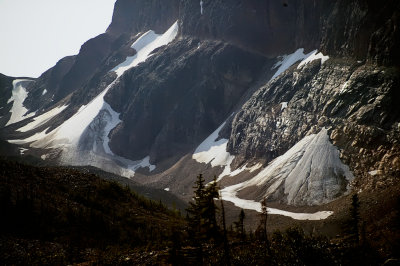 Mount Edith Clavell Base |
 Mount Edith Clavell (BW) |
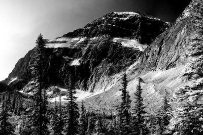
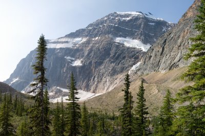
 Mt. Edith Clavell, Jasper National Park, Alberta | Approximately 1 Km to Angel Glacier and 2.5 Km to peak of Mt Clavell Best viewed on Original Size |
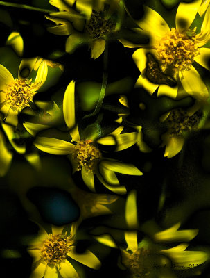
 WEB_Alpine_Flowers.jpg |
|||
 Maligne Canyon, Jasper National Park. Alberta |
 Maligne Canyon, Jasper National Park. Alberta |
 Maligne Canyon, Jasper National Park. Alberta |
Medicine Lake, Jasper National Park, Alberta | A lake that is said to have no outlet. Full in Spring and by Fall, empty. It is thought that it drains through an underground river. Best viewed on Original Size |
|||
 Foggy Mushbowl Falls |
 Douglas Falls BC | Downstream of the falls on a very cloudy (misty) morning |  Helmcken Falls, BC | So misty, all that could be seen. This was the converse of the old saying "Seen but not heard" |  Hanging Moss (Helmcken Falls) |
||
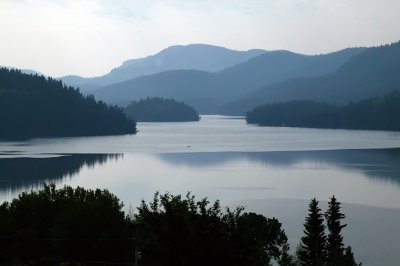 Lac Des Roches, south-east direction |
 web_lacdesroches.jpg |
Kelly Lake |
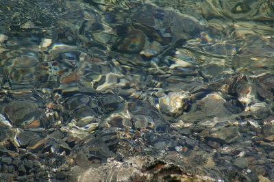 Crystal Clear (Kelly lake) |
||||
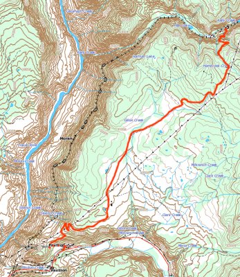 WEB_kelly2pavilion.jpg | The tortuous path over the mountains on a dirt road with severe altitude changes and many switcbacks.
|
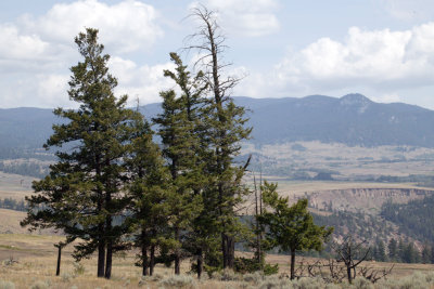 Sparse growth |
 Sparse Growth |
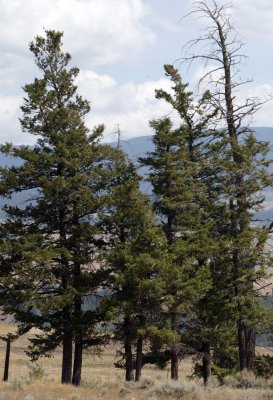
 High Country |
|||
 Spider Web |
 Binding a Nation |
 Shillouette |
 WEB_Road-to-Lilloet.jpg |
||||
 WEB_Costal-Range.jpg |
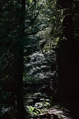 What Light Through the Forest Breaks |
 Downstream of Bridal Falls |
 Bridal Falls, BC |
||||
 Bridal Veil (Bridal Falls) |
 Verdant Growth |
 Bridal Falls, BC | Best viewed on Large Size |
 Downstream of Bridal Falls, BC |
|||
 Lush Forest Growth |
 WEB_BW_Bridal_Falls02.jpg |
 Effect of Pine Beetles |
 Helmcken Falls |
||||
 WEB_AA_1E6V6771.jpg |
 WEB_Upper_Lower_Helmcken.jpg |
 WEB_Helmckenx2_Panorama2.jpg |
 WEB_Helmcken_sharp.jpg |
||||
 At-The-Brink, Douglas Falls |
 Douglas Falls BC | At the edge of the base of the falls
Best viewed on Original Size |
Spahats Falls |
 Moul Falls |
|||
 Helmcken Falls |
 Upper Sunwapta Falls on the Sunwapta River | At 54 Km south of Jasper. A 15 minute walk to the Lower Falls.
|
 Short Field Landing |
Panorama West of Rogers Pass | Stretching from Illecillewaet Glacer on the left to Lily Glacier on the left. Made up of Sir MacDonald Range, including Lookout Mountain, Youngs Peak, Asukan Ridge, Leda and Castor Peaks | ||
 West From Rogers Pass | Best viewed on Original Size |
 Rogers Pass Panorama | A combined format indicating the landmarks. Taken facing back to the west. Made from four composite photographs. |  WEB_Composite_1E6V6678.jpg |
 WEB_Rogers_BW_Paanorama.jpg |
||
Illecillwaaet Glacer to Asulkan Glacier |
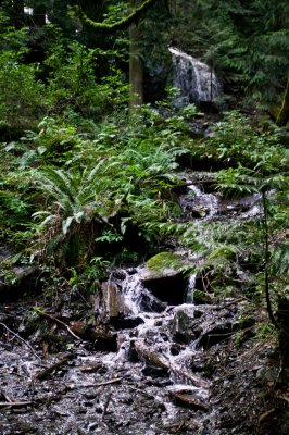
 Creek in Skunk Cabbage |
 Skunk Cabbage Boardwalk | Eight exposure of bullrushes, each at a different focal plane and then combined using Helicon Focus. This technique yielded ann effective focal zone of 20 feet, with the nearest approximately 3 feet from the lens. |
 Skunk Cabbage Foliage |
|||
 WaptaFalls, Yoho National Park, BC | Best viewed on Original Size |
 WEB_Wapta_Falls.02.jpg |
 Web_naturalBridge.jpg |
 Natural Stone Bridge |
|||
Turmoil Upstream of Natural Bridge |
 Van Home Range from Natural Bridge | Best viewed on Original Size
|
 EmeraldLake, Yoho National Park, BC | Best viewed on Original Size |
 Three of a Kind | Best viewed on Large Size |
|
 Bird of Prey, Saskatchewan |
 Tilted Lines, Saskatchewan |
 Tilted B& W |
 Roadside Flowers, Saskatchewan |
| previous page | pages 1 2 3 4 5 6 7 8 9 10 11 12 ALL | next page |
| comment | share |