


|
|
|
|
|
|
| RJB Graphics | profile | all galleries >> Me, My and Myself >> The Western Tour 2009-2011 | tree view | thumbnails | slideshow | map |
An urge to go west "young man".. Alberta and British Columbia: Mountains and Waterfalls
Currently more or less in random order, but am working to place in chronologic sequence and finish filling out the portfolio.
Start viewing the picture in the "large" format. If the picture is a panorama and much wider than high, there should be an instruction to click on the "original size". That will give better viewing. At times there are variants of the picture, usually to a high contrast Black & White ala Ansell Adams.
Please comment on the pictures (like or hate).
| previous page | pages 1 2 3 4 5 6 7 8 9 10 11 12 ALL | next page |
 Lush Forest Growth |
 WEB_BW_Bridal_Falls02.jpg |
 Effect of Pine Beetles |
 Helmcken Falls |
||
 WEB_AA_1E6V6771.jpg |
 WEB_Upper_Lower_Helmcken.jpg |
 WEB_Helmckenx2_Panorama2.jpg |
 WEB_Helmcken_sharp.jpg |
||
 At-The-Brink, Douglas Falls |
 Douglas Falls BC | At the edge of the base of the falls
Best viewed on Original Size |
Spahats Falls |
 Moul Falls |
|
 Helmcken Falls |
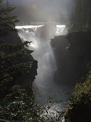 Upper Sunwapta Falls on the Sunwapta River | At 54 Km south of Jasper. A 15 minute walk to the Lower Falls.
|
 Short Field Landing |
Panorama West of Rogers Pass | Stretching from Illecillewaet Glacer on the left to Lily Glacier on the left. Made up of Sir MacDonald Range, including Lookout Mountain, Youngs Peak, Asukan Ridge, Leda and Castor Peaks |
 West From Rogers Pass | Best viewed on Original Size |
 Rogers Pass Panorama | A combined format indicating the landmarks. Taken facing back to the west. Made from four composite photographs. |  WEB_Composite_1E6V6678.jpg |
 WEB_Rogers_BW_Paanorama.jpg |
| previous page | pages 1 2 3 4 5 6 7 8 9 10 11 12 ALL | next page |
| comment | share |