Updates: Wait for further notice!
TENTATIVE LIST:
Hosts-----------------------------Guests
01. Chad Fronteras----------------01. Rex Lacdaying
02. Andre Tubungbanua------------02. Miriam Datugan
03. Loyd Gulfan--------------------03. Cesar Datugan
04. Nove Gulfan--------------------04.
05. Khennjo Deles------------------05.
06. Ariel Jay Genon-----------------06.
07. Haneka Enerio
08. Jerson Paican
09. Sherwin Pairat
10.
11.
12.
13.
14.
15.
-o-
-o-
-o-
RECENT DEVELOPMENTS:
-o-
► 10/06: Updated (Modified) the itinerary
► 09/30: DENR limits only 20 persons per group
► 09/28: Guide fee is P350.00 per day
► 09/24: End of Ramadan is Sept30 not Oct13, this climb was affected.
► 06/26: Actual checked the Manila-Naga fare, P490 but it's ordinary buses it will take longer than 8 hours.
► 06/25: Reduced the Guide Fee from P125 to 60.00 (that is 300 per day x 2 day = 600 divide 10 climbers)
► 06/25: Cagayan Valley Sanitarium (Nueva Ecija) climbers show interest on this trek. They were with us in Mt. Pulag.
► 06/24: Changed the DENR fee from P50.00 to the P100
-o-
-o-
A FRIENDLY REMINDER:
► This event is strictly NO cigarette NO Liquor climb
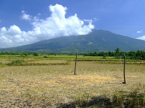
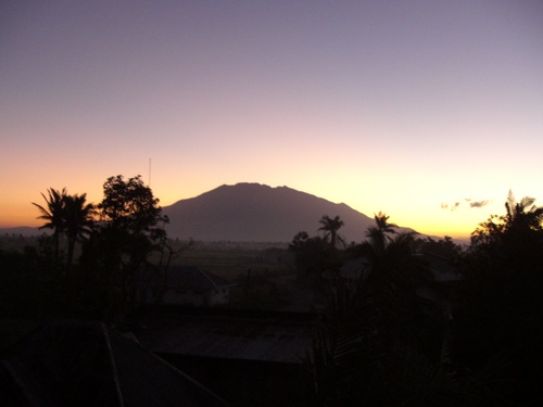
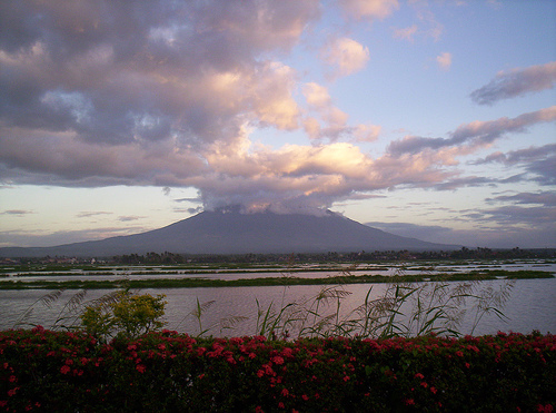
The Itinerary
ITINERARY
o----
DAY 0: MMMM DD, YYYY (THURSDAY)
08:00 PM Assembly Cubao Bus Terminal bound for Naga City (behind Ali Mall)
09:00 PM ETD (Estmd Time of Departure) from Manila to Naga City
10PM-05AM Travel by bus from Manila to Naga City
o----
DAY 1: MMMM DD, YYYY (FRIDAY)
05:00 AM Arrival in Naga City Bus Terminal/Breakfast
07:30 AM ETD for Bgy. Panicuason, Naga City
08:30 AM ETA (Estmd Time of Arrival) Bgy. Panicuason, Naga City
09:00 AM ETA Mt. Isarog DENR outpost/Log In/Pay Entrance Fee
10:00 AM Start Trek
12:30 AM ETA Camp 1/Lunch/Tent Pitching and Camp management
01:30 PM Sidetrip #1: Explore & Swimming: Malabsay Falls, Nabuntulan Falls, Jakuzi Falls
06:00 PM Dinner, Socials, Worship
o----
DAY 2: MMMM DD, YYYY (SATURDAY)
03:00 AM Wake-up call/ Breakfast and Lunch Preparation
05:00 AM Final Assault to Summit
09:00 AM ETA Summit of Mt. Isarog
10:00 AM Descend to Base Camp
01:00 NN ETA Camp1: Lunch/Break Camp
02:00 PM Start Descend
03:00 PM ETA DENR Outpost/Log Out
04:00 PM Proceed to Naga View College
05:00 PM ETD: Naga View College campus
06:00 PM Tent Pitch, stroll the campus, dinner
08:00 PM Sleep at Naga View College
o----
DAY 3: MMMM DD, YYYY (SUNDAY: Sidetrip #2 - GOTA White Beach!)
04:30 AM Wake Up Call
05:30 AM Proceed to Naga City
06:00 AM Breakfast
06:15 AM Depart Naga to Caramoan
08:00 AM Arrive in Sabang Port
09:00 AM Depart Sabang
11:00 AM Arrive in Guijalo Port, Caramoan
Lunch
12:00 NN Arrive in Gota Beach or Taniman Beach
01:30 PM Island Hopping (Gota Beach White/Rock Islands)
06:00 Pitch Tent
DAY 4: MMMM DD, YYYY (MONDAY: Sidetrip #2 - Swimming White Beach!)
05:30 AM Wake Up Call
06:00 AM Swimming, Breakfast
10:30 AM Proceed back to Guijalo Port
02:00 PM Arrive in Naga City
03:30 PM Depart for Manila
The Sidetrips
>oooo<
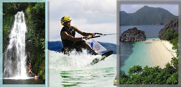
WATERFALLS
Mt. Isarog National Park is furnished by nature with many natural waterfalls and springs. The Malabsay Waterfalls is located near Mt. Isarog National Park�s entrance. Here, visitors can go swimming and have picnics with friends and family. The Nabuntulan Spring is not far from Malabsay Waterfalls. The Magragobrob Waterfalls is found inside Mt. Isarog�s crater on the Goa side of Mt. Isarog National Park. A 40-meter waterfall that emanates sulfuric waters down to Rangas River. Hikers usually rest here. The Hiwacloy Sulfur Springs is found here where the warm sulfuric water is believe to cure minor ailments.
>oooo<
>oooo<
WHITE BEACH
GOTA Beach is part of the 347-hectare Caramoan National Park, it is composed of two coves, the Small Gota Beach (to which the road from the town connects), and the Large Gota Beach to the north (which serves as a jumping point for island-hopping). It is believed to be the location of the filming the French edition of Survivor Series.
The imposing stretch of mountainous rock formations which towers from the powdery white sand half-enclosing the beach adds beauty to its islets-cluttered seascapes.
The Budget
Fare & Fees
0,700.00 Manila to Naga
0,075.00 Naga to Jump-Off
0,100.00 DENR Fee
0,060.00 Guide Fee
0,075.00 Jump-Off back to Naga
0,080.00 Naga to Gota Beach, Caramoan
0,120.00 Entrance Fee: Gota Beach
0,200.00 Island Hopping boat Fee
0,140.00 Caramoan to Naga
0,700.00 Naga back to Manila
0,550.00 Extra Money
x======
2,800.00 TOTAL
x======
>oooo<
Meals
THURS
Dinner - Jolibee, Cubao, Manila
-o-
FRIDAY
B-fast - Naga
Lunch - At Waterfalls
Dinner - At Camp
-o-
SATURDAY
B-fast - At Camp
Lunch - At Trail
Dinner - Naga
-o-
SUNDAY
B-fast - At Beach
Lunch - At Beach
Dinner - On the road going back to Manila