


|
|
|
|
|
|
| |
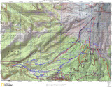
Here is a topo map of the same area.
The points labeled Bowl and Canyon are based on waypoints given to us from Alan. These are clearly
above Mississippi Head.
The point labeled TOP is where I traversed over from The Mile last year, this is where a bunch of pictures were taken that I included at the end.
Just above the line from OB Mile to TOP is a point marked crossing, which is where an easy crossing is located across little Zig Zag
All images are copyrighted, please request before using