


|
|
|
|
|
|
| |
| 27-Jul-2012 | |
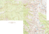
Red highlighting shows the route taken by most of the group.
Camps are shown by red circles.
The last night's camp was in luxury, at the Bearpaw High Sierra Camp:
http://www.visitsequoia.com/bearpaw.aspx
On the last day, three of the fastest walkers did a harder hike back to the starting point to get the cars (green highlighting).
Total distance was about 45 miles for the red route, or 48 miles for the car shuttlers.
| comment | |