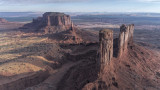
A merge of 3 exposures from one of the drone flights near Brigham's Tomb (background left) and
the Stagecoach (foreground right) butte formations along the western edge of Monument Valley.
And I have finished a quick edit of a highlight reel from the various drone flights on my trip to view the eclipse.
Each segment is presented in chronological order and I will be working on individual location videos in the coming weeks (ok, probably months).
Best viewed in full screen mode in HD 1080p. If you only want to view in the window in PBase then 720p is probably ok.
For those that want to see in 4K resolution I guess you will have to get that here because I can't seem to get YouTube to display that for me.
Shot on location (in order of appearance) at:
Grand Falls, Coconino County, AZ
Kayenta, AZ
Monument Valley, Navajo County, AZ
Coal Mine Canyon, Coconino County, AZ
Mexican Hat, San Juan County, UT
Valley of the Gods, San Juan County, UT
Lake Powell Recreation Area, San Juan County, UT
Goblin Valley State Park, Emery County, UT
Colorado Riverway, Moab, UT
Shoshone Falls State Park, Twin Falls, ID
Mitchell, OR
Lake Siskiyou, Siskiyou County, CA
NV Rt. 338, Lyon County, NV
Mono County, CA
Joshua Tree Parkway, Mohave County, AZ
An amazing perspective of this land. Almost a magical view shot from the drone. This is a view few people are lucky enough to see. Thanks so much for showing this image. VV
a thrilling view enriched by a double perspective...love the smooth and gentle pace of the video too...you certainly covered a lot of ground on this trip..
Absolutely fabulous video footage has been captured by the use of the drone Sam. Together with fantastic sound. Have already watched several times. David.