


|
|
|
|
|
|
| |
| 13-FEB-2011 | |
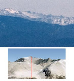
This shows a 1:1 blow-up of a small section of the previous panorama,
along with a Google Earth view of Mt. Whitney. The red line shows the
line of sight from where the picture was taken. You can make out the
profile of Mt. Whitney and its adjoining peaks, 125 miles away. I
believe this place, where route 33 descends into Maricopa, is the only
spot on the west side of the Central Valley from where Mt. Whitney is
visible through a gap in the closer mountains.
© Paul D. DeRocco: No unauthorised reproduction of any images is permitted.
| comment | |