


|
|
|
|
|
|
| |
| 15-JAN-2008 | |
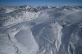
The glacier at L center/foreground is located at 50° 57' 18"N, 123° 58' 29"W.
The image shows the glaciated region sitting to the N of the terminus of the
Stanley Smith Glacier, between Edmond Creek (51° 02' 10"N, 123° 57' 27"W) and
the Bishop River (50° 57' 50"N, 124° 11' 21"W).
Note that many of the features shown are unnamed.
The prominent snowy peak at upper R center is probably Peak 9483 (50° 56' 56"N, 123° 52' 44"W).
Monmouth (50° 59' 32"N, 123° 47' 28"W) is the prominent rocky peak at upper L distance.
Copyright 2002-2023, John H. Scurlock, Photographer/Pilot