


|
|
|
|
|
|
| |
| 15-MAY-2007 | |
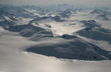
Photograph location (est): 51°11'32.62"N 124°42'59.92"W
Sundial (51°10'59.88"N 124°35'8.16"W) is at upper center, just beyond the glacier at center.
Nunatak (51°10'17.04"N 124°39'27.00"W) is the R end of the pk in the foreground, and is out of the image.
The view looks E. Queen Bess Glacier is visible at upper R.
| Full EXIF Info | |
| Date/Time | 15-May-2007 08:40:19 |
| Make | Canon |
| Model | Canon EOS DIGITAL REBEL XTi |
| Flash Used | No |
| Focal Length | 31 mm |
| Exposure Time | 1/4000 sec |
| Aperture | f/7.1 |
| ISO Equivalent | 200 |
| Exposure Bias | |
| White Balance | |
| Metering Mode | average (1) |
| JPEG Quality | |
| Exposure Program | aperture priority (3) |
| Focus Distance | |
Copyright 2002-2023, John H. Scurlock, Photographer/Pilot