


|
|
|
|
|
|
| |
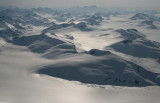
| 15-MAY-2007 | |
Photograph location (est): 51°11'32.62"N 124°42'59.92"W
Sundial (51°10'59.88"N 124°35'8.16"W) is at upper center, just beyond the glacier at center.
Nunatak (51°10'17.04"N 124°39'27.00"W) is the R end of the pk in the foreground, and is out of the image.
The view looks E. Queen Bess Glacier is visible at upper R.
Copyright 2002-2025, John H. Scurlock, Photographer/Pilot