


|
|
|
|
|
|
| |
| 20-AUG-2015 | |
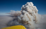
The airplane is flying at about 14,500', fifteen miles southeast from the town of Tonasket.
The fire has exploded upwards to nearly 20,000' through a lower,
dense smoke layer that tops out at about 12,000'.
The view looks to the northeast.
Copyright 2002-2026, John H. Scurlock, Photographer/Pilot