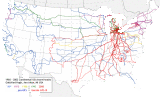
This map is an Albers Equal Area projection of the contiguous United States, centered on 100 West longitude. The post-February, 1998 tracks (in red) were captured with a Garmin GPS-III. The earlier tracks are reconstructed from Gottfried's old, pre-GPS records. These are about 90% complete as far as the various records he kept since about 1957. While the overall data (even for the older records) are quite good, these obviously are not as precise in space and time as are the GPS generated tracks. The two, unconnected 'blips' on the northwestern border are from side trips down into Glacier National (International Peace) Park from Alberta (in a 1967 VW Squareback; 20 June 1968), and along the beautiful Okanogan Valley from British Columbia, Canada. A much more recent trip to the Puget Sound area (19-25 August 1999) is tracked in overall fashion as is a Montana segment where the 1986 Porsche 911 Carrera was able to perform on the road.
All images are protected and, except with the prior written consent of the author, may not be reproduced or otherwise used.