05-NOV-2011
The end of the road
It was interesting driving to Las Vegas. I hadn’t driven over 35 mph for eleven days and suddenly the speed limit was 75 mph. I certainly covered more ground than I had been while hiking. What was I thinking all of that time? Who walks these days? Besides, all of that hiking seems to have dropped a few pounds from my already too skinny frame. What kind of American am I? We’re supposed to eat ribs not show them. So I went on the buffet diet while in Las Vegas. I had ribs and prime rib. I even had someone ask me if I was from the south because of the way I was devouring a plate of crawdads. I have continued with my new nutrition program at home. Yesterday we went to an Oriental buffet.
I think I may have already talked about this, but my one regret from this trip is that I was not able to hike The Narrows. If the water levels had been somewhere near normal I would have at least attempted to see if my knees would hold up. But with the Virgin River running so high, I knew that it just wasn’t going to be possible. Maybe I’ll return some year to experience the Narrows. If I do come back maybe the color will be better too. There are some places I would want to revisit and some that I’m content to see just once. I would like to hike portions of the West and or East Rim trails. The view of those towers is impressive from the valley, but I would like to get a different perspective. And perhaps some day I’ll feel up to attempting to hike to The Subway (assuming that I would be able to get one of the limited number of permits).
Oh and by the way I happened to stumble upon this picture.
I think that’s my car down there. I was in that area that afternoon. It’s a much more scenic parking place than my garage. My car has been good to me. I’ll have to come up with some other nice places to park it. Going along for the ride is fun for me too.
12-NOV-2011
The Invalid Highway
During my partial hike up the West Rim Trail I happened to hear someone say, “the invalid highway”. I’m not sure what the context was since I was the only one who was hobbling on that trail. The masses of people who passed me seemed to be in fine health. Why do I mention this? Although I spent a few invalid days, I was still able to get out and do a lot of really cool stuff on the other days. Well to be fair I saw cool stuff every day. What I mean is that I was able to go to some places that were out of the way and certainly not seen by the vast majority of visitors to Zion National Park. I have to admit that right before this trip I wasn’t at all looking forward to it the way I usually do before a vacation. This was to be my first solo trip in a long time. It’s just not the same when you don’t have someone to share it with. After my knee problems on my first hiking day I was feeling pretty unhappy. What in the world was I going to do on that many days if I wasn’t able to hike? And not just hike. I needed to be able to scramble through routes much more often than hiking on real trails.
Overall the trip worked out being pretty darn good even if I didn’t get the great fall color that I was hoping for. I didn’t even end up capturing the kind of images that I would have wanted at most of the places I saw. Don’t get me wrong. I did get some that I’m very happy with. I think that most of all I have just enjoyed being here. To paraphrase a poem I once read, “I love Cheryl, but I can do great things without her.” I realize that could be misinterpreted. What I mean is not that I have to be without her to great things but rather that I can do great things even on my own.
12-NOV-2011
This is my reality
Yesterday I happened to think about 5 mm. I can convert to Imperial and visualize because of the kind of work that I do. Oh that’s right, I work for a living. When you’re on vacation it’s easy to completely forget about work. I suppose that’s what they mean by the term getting away from it all. I’ve definitely gotten comfortable here. Although I’ve been to Zion before, my first drive through the east side a little over a week ago didn’t bring a lot of familiarity. Sure I recognized some things, but I didn’t have context. Now when I drive through I’ll spot lots of things and think, “I’ve been down there”, or “I’ve been up there”, or (fill in the blank) is in that direction. The east side has become home to me. It’s a shame to think that I’m leaving tomorrow and that the next time I visit the scenery all along the road will not bring immediate recognition of exactly where I am.
The park was much less crowded this morning than I would have expected during a holiday weekend with free admission. A lot of people did show up a little bit later. Once again I found myself in the main canyon during a weekend. Since I had already covered most of the hikes I had planned I mostly did the tourist thing today. Of course I did have the option of making another attempt at the West Rim Trail. The worst case scenario would be finding myself at my destination right when knee pain set in. The possibility of having to descend two thousand feet with knee pain pretty much nixed that idea.
I spent some quality time with does up on the maple grove hillside south of the Weeping Wall.
I returned to the Temple of Sinewava to see if the color had gotten any better. It really hadn’t, so I just walked alongside the river for a little bit without taking any pictures.
I descended to Pine Creek from the second switchback. Trying to make my way upstream was tough going. Man there are a lot of boulders down there. I didn’t really get very far before I was in a spot where I was standing on a rock in the creek needing to jump to another which wasn’t very far. But it was slanted and to slip (not very likely) would mean falling into water deep enough to ruin my camera gear. The prospect of more and more of that made me turn around. This section of Pine Creek has been the only stream with running water. For some reason it had been easier following dry drainages up to this point.
I spent a little bit of time at the visitor center courtyard. I’ve always thought that they did a really nice job. I also went to the Human History Museum. I found it interesting that they had a sign stating that the bottle filling station was closed for the season. I suppose that must be the dry season. No one drinks water at this time of year right? It wasn’t a problem though since there’s a drinking fountain right around the corner.
I really needed to hike by this point. The Watchman Trail has always been somewhat low on my list of priorities. For this trip I had it designated as an unlikely possibility. But hey it was there and so was I, so off I went. For the most part it was what I had expected – something that I would only do once. However I have to say that I really enjoyed the view from up top of that little butte. I spent quite a while up there just taking it in. I would have enjoyed it regardless of the situation, but I suspect that part of the allure was that it was pretty much my last hurrah at Zion. On the way down I was thinking, “Hey you know I could drive over to the Northgate Peaks trail on my way out of town tomorrow. That’s only a four mile hike.” But it’s slightly out of my way, so I guess that my hiking is over for the time being. I could also go to Valley of Fire on my way to Las Vegas, but I’m just going to wait until December.
So that’s it. I’ll have a couple of days of R&R before I head home. I probably need the rest by now. Oh and that reality thing? I don’t need to worry about reality right now. I’m still on vacation.
11-NOV-2011
I have reached…
…My goal? Or my limit? All I can say is that my body is tired.
Today was overcast with a very bland sky. I explored the drainage between Checkerboard Mesa and Crazy Quilt Mesa. I told myself multiple times that I’m just going to turn around. The first time was when I reached an obstacle, backtracked, and followed a rough path up a steep hillside covered with loose dirt and rocks with lots of brush to boot. I didn’t know when the end would be in sight. I climbed back down. Then I went back to the obstacle and scouted the hill. Oh there’s an easier path. So onward I went. My body was really feeling the effects of the exertion of the past days.
Something interesting happened the other day. I was in a spot where I knew that I should look for my exit point and right after that I happened to see that someone had piled up rocks into a small cairn. So today after I came down a place where I thought wasn’t going to be very obvious during my return I made a small cairn.
I came to the head of the drainage and was looking at a tall hill. No way. I thought this has been difficult enough. I’m going to turn around. I just don’t have the energy. So obviously I started climbing. From the bottom you can’t always tell what you’ll find when you reach the highest point you can see. Sometimes the route continues up and up. But I was right in thinking that I was looking at the top of the saddle.
The view looking north from the saddle was great. Unfortunately today’s light wasn’t great so I didn’t get any good pictures. I looked down to the south and the vista isn’t quite so good in that direction. I decided that I was just too tired to continue down that way. I had told myself that I was just going to go as far as the saddle. And of course I continued down. I told myself that it was just for a short distance so that I could see if views opened up. Well that short distance continued until I had climbed down quite a way and rounded the back side of Checkerboard Mesa. The views back there were spectacular too. Too bad I didn’t get any good pictures.
I got to the viewpoint of Checkerboard Arch and this time I really did decide to head back. I could have continued to what I had read was a good viewpoint of Parunuweap Canyon, but I just didn’t have the energy and I still had to get myself back to my car. Besides I know that I want to come back some year. Up until I had reached the saddle I felt that this was going to be a one time hike. But once I got up there I knew that I would need to come back on a day when I could get some nice photos. So whenever that happens I’ll go to the Parunuweap viewpoint as well.
On my way back I ran into a couple of canyoneers headed to Fat Man’s Misery. I also happened to get my second wind. I was dragging a whole lot less. Maybe I should have hiked farther after all. The climb back up to the saddle wasn’t too bad. Going down on the snowy side was a little slippery. I had just taken my Yaktrax out of my pack yesterday before my night time hike to the Canyon Overlook.
Oh I should mention that last night I was very glad that I had made a recon hike to the Overlook during the day. It was a whole lot easier finding the route in the dark when I was familiar with it. My headlamp is a lot better for finding my footing than for finding my route.
Okay back to today’s events. I was just starting to think that I needed to start looking for my route up a hill when I spotted my little cairn. Did I mention that the spot didn’t look like a good exit? If I hadn’t seen the cairn I would have gone back and investigated a place that looked like an easier climb although I didn’t know how much brush I would have had to wade through to get back to the rough path.
To make a long story a little less long (I surely cannot call it “short” at this point), the hike back to my car sure felt a whole lot easier both physically as well as not seeming to be that rough a route.
I’ve been spotting the search and rescue team training in various places pretty much all this week. Today they were in one of the tunnel galleries.
I considered descending to Pine Creek from the second switchback and finding a route upstream. I figured that I probably had plenty of time, but I decided to take it easy and just go on the short hike to the waterfall from the lowest switchback. It was nice to be near a creek with running water. Other than Keyhole Canyon the other day all of the drainages have been dry. The Virgin River excepted of course. Well I shouldn’t say dry. I’ve had to bypass pools, but the creeks haven’t been flowing. That’s a good thing since I wouldn’t have been able to make those hikes when the creeks were running since I was hiking in the middle of the watercourses.
So what exactly have I reached? I’ve hiked the majority of the routes I had planned with one glaring exception. Tomorrow may bring rain. I’ll see how it looks. I may go to that section of Pine Creek I mentioned earlier. I don’t have many good options left considering the conditions. The cottonwoods aren’t showing good color this year. Most haven’t turned and many have dropped their leaves. What I would really like is for tomorrow to bring a gully washer. I was hoping for that to happen some time during this trip, but it appears that tomorrow’s possible rainfall won’t fit the bill.
I expect that I’ll probably be mostly taking it easy tomorrow. Unfortunately, as I mentioned the easy stuff in the canyon won’t be overly appealing in the absence of good color. I don’t expect it to look a whole lot different from what I’ve already seen. Everyone should have my problems, right?
10-NOV-2011
I'm not taking pictures
My wristwatch alarm went off this morning and the first thought I had was, “I’m not taking pictures.” You see I had been using my watch to time bulb exposures of the nighttime landscapes. It’s the same chime, but noticeably less enjoyable when it signals time to get out of bed. Come to think of it when my watch timer chimes that’s a good thing too. It’s kind of cold standing out there waiting for the exposure to finish.
My first hike was to the Canyon Overlook. That’s the only real trail on the east side until you reach the trailhead at the east entrance. That particular trail branches off in several directions and all of them are fairly long for day hikes. The scenery out that way isn’t exactly why I came to Zion. If I ever do any of those hikes it would only be for the destination and not for the journey. So anyway, I finally got around to the Canyon Overlook Trail. The main reason I wanted to do it was for daytime scouting and planning. I figured that it wouldn’t be too easy setting up shots in the dark. My plan is to return tonight. The sky clouded up this afternoon so I may wait until tomorrow. We’ll see.
My next destination was Shelf Canyon. I didn’t even expect to get to the interesting part. I read that I would have to wade through water. How deep I don’t know. Of course there may have been ice on top, although certainly not enough to support my weight. I decided that I might as well just go and see as much I could before I had to turn around. I didn’t even make it to the water. I ended up stopping at a steeply slanted slickrock wall I would have needed to traverse in order to climb past an obstacle. Maybe I’ll come back if I ever get shoes with stickier soles. Unlike yesterday’s attempt at Two Pines Arch, Shelf Canyon is something that I definitely want to eventually see.
I had planned to go to Separation Canyon next. However I had a hankering to see what Jolley Gulch was like. I don’t know why. I just really felt like going. The trailhead is the one I spoke of earlier. But to get to Jolley Gulch one leaves the trail after a bit over a half mile. (I think it was closer to 5/8 mile, but who’s counting?) So there I was walking over cobbles. I guess that Clear Creek must have imprinted me with the need to do that.
I saw several spots that I wanted to explore on my way back. But for the time being I continued. The scenery gets interesting at the end, although I didn’t reach all the way to the dryfall wall. I turned around at some chock stones in a short slot. I think it wouldn’t have been too much trouble to continue, but I decided to retreat anyway.
On the way out I soon came to a slickrock section. I wanted to see if I could access an area above and beyond so up I went. And up. And up. I had already climbed a long way when I got the brilliant idea that I could continue up to the rim of the canyon and find the East Rim Trail instead of having to work my way down the slickrock slope. I have no idea why I considered that as being possible. The probability is that I would come to some sheer wall or obstacle which would end my progress and then I would have even farther to climb down. And yet I continued. Hope springs eternal. And by now I was definitely praying that I would find a way up. It’s not as though I couldn’t work my way down, but I really didn’t want to do it. I finally made it to the rim. Whew! I was breathing hard (which hasn’t been all that unusual while I was climbing at this elevation. After all I live at sea level.) Now I just had to bushwhack through the brush until I could find the trail. I knew that there was no way I could get lost. I could travel in two directions and find it. The only question was how much brush I was going to have to travel through in order to get there. I was happy when I saw it.
So now I just had to travel down a real trail back to my car. Of course the trail just happened to be a much longer route than if I had continued back downstream in Jolley Gulch. But I knew this before I made my decision.
I stopped for a view down the wall into the narrow section of the gulch. Then I stopped for a snack. I took off my pack and found that it was just covered with dust, leaves, and twigs. Back on the trail I have to say that this section of Zion sure is different than the areas I had previously been visiting. It’s mostly ponderosa and juniper. Sure there are occasional views of beautiful cliffs, but other than that it wasn’t drastically different from back home. Of course we have a lot less trees, but if you had been there you would know what I mean.
One other thing that I wanted to accomplish was to see a portion of Cave Canyon. The trail passes through it, although the other hike is the section just to the northeast. This recon dropped that hike waaay down on my priority list. Speaking of priorities, the view from the Canyon Overlook Trail moved Lower Pine Creek way up my list. I was already planning to do the short section from the lowest switchback. But now I’ll either see if I can continue from that point or take another hike from the second switchback. Of course it’s nothing like what the canyoneers see when they descend through the slot, but that sort of thing is well beyond my capabilities. I’ll stick to what I think is reasonable for me and enjoy every minute of it.
09-NOV-2011
Waste of Time Canyon
I wanted to hike the drainage between Checkerboard Mesa and Crazy Quilt Mesa, but there's still some snow there. I don't really know what the route is like except that there is at least one slickrock scramble. I didn't feel like doing that if it was icy. So I explored some other spots in that vicinity.
First up was Hidden Arch. It was on my options list as just a fill in hike. I wasn't too interested in the arch itself, but I figured that I might want to explore the area. So I headed up to a canyon first. I decided to name it Waste of Time Canyon. Now was it really a waste of time? Only with the consideration that I could have been doing something else. It's not as though it wasn't an enjoyable place to be.
I went looking for Hidden Arch on the way back. I ended up on a hill with steep slopes below me. I turned around and there it was. Now that I knew where to find it, it was obviously visible from much farther away.
Next up was another visit to the hoodoos. I guess I must like them or something. I then explored the canyon to the north. I didn't know anything except that it's shown on the topo map and I could see it when I was up at the hoodoos. I didn't have any particular destination. I ended up turning back at a spot where someone had stacked some rocks so that they could use them as a step and climb up a large rock, which was lodged in the canyon walls hindering progress. I decided that would be a good turn around point.
I had been wanting to return to the area above Petroglyph Canyon. I checked it out yesterday but the afternoon shadows weren't what I wanted. Today I was there at a good time for getting the light I wanted. So that's my picture of the day.
There was a group of about a dozen people descending the steep slickrock wall on the west side. I talked to one of them when they got down. He's from Canada. Also in the group were folks from Washington and Utah. I'm guessing that the locals chose the route. They had hiked up the Many Pools drainage and climbed the east slickrock slope to cross over here. If I felt like climbing a slope like that I would have climbed the one to the east of this spot. That one is between Aires Butte and South Ariel Peak. Rumor has it that the Center of the Universe is up there.
I finished the day attempting to find Two Pines Arch. Not that I was really interested in actually seeing it. This was another item that was very low on my options list. But the hike was short so I figured that I could easily fit it in. That was a mistake. First of all I figured that the arch was in the drainage east of where my maps showed the route. I decided to follow the maps and route description. The climb was a pain and I attempted one aborted route thinking that it might be the easiest way to ascend even though it wasn't exactly headed in the right direction. I got to a place with weak looking sandstone and wondered why I was bothering since I didn't really want to see the arch anyway. The only reason I considered it was to see what the scenery was like. It wasn't anything to write home about. The only thing worth mentioning is that I was higher above the road than I thought. No wonder I was breathing hard. So I turned around and headed back down.
Wait a minute, that looks like another possible route. Okay I'll give it one more shot. It was well before sunset, but I really didn't want to have to find my way down once the sun went behind the mountain so I was really hurrying. I ended up cliffed out about 300 feet from the arch. I was above the eastern drainage that I had mentioned earlier. Maybe I'm just blind, but I didn't see anything. I didn't spend much time looking. I actually did have plenty of light left, but I didn't want to screw around so I got my tired self down. Maybe I should have titled this entry Waste of Time Arch.
08-NOV-2011
Search and Rescue Operation
My new hiking friend Jim went back to West Virginia today. I sure am going to miss discussing our hikes at breakfast or whenever we happened to run into each other.
The morning was clear and frosty. I'm glad that I brought an ice scraper with me. What had been soft sand felt like uneven concrete this morning. And speaking of sand, I happened to break through the frozen crust into some almost quicksand one time. Shortly after I started my hike I decided that my fingers were so cold that I needed to break out a hand warmer pack. I did that and then I realized that my hands were warmer with my gloves off. That shows you how much a southern California boy knows about the cold. I guess it wasn't a good idea to leave my gloves in the car to freeze overnight.
First up on today's agenda was Cascading Falls. It was very appropriately named. There wasn't any water flowing today, but if it was wet there would have been plenty of cascades. As it was, the potholes were frozen over. I'm glad that the sandstone wasn't frosty. I started out a little late this morning because I wanted to let things warm up at least a little. In any case, I'm pretty sure that I won't ever be hiking this route when I would have to be climbing slickrock in the water.
The potholes weren't as photogenic as I had hoped. Or maybe the fault lies with me. Still, it was very nice to see the area in person. The slot had a lot of colorful leaves on the ground. It might have made for nice pictures if the day had been overcast. Those trees and bushes didn't seem to like me very much. It was get grabbed and scratched by branches day. One time I had a branch grab my hair and not let go. I knew something was up when it was still holding on after I had moved forward a bit. Once I got out of the branches I reached up and removed the broken branch that was stuck to me.
I made it to a spot in a tight slot where I would have had to climb about six feet as well as negotiate a two foot chock stone lodged at the top. I haven't even seen 127 Hours. No chance I want to live it.
As I was descending a slickrock hill (which seemed to be only a slightly better choice than the watercourse I had climbed on my way up) I noticed some people with canyoneering helmets up on a ridge near the road. There was some huge tripod set up near the edge. When I climbed up towards my car I saw a half dozen Park Ranger SUVs as well as a Search and Rescue vehicle. Apparently they must have been training. Gee and to think that I wasted an opportunity to need rescue when it was so close at hand.
I don't think that I got many good photos at Cascading Falls, although I sure did enjoy the hike.
My next hike was Many Pools. It was fantastic. I made an unfortunate decision when I was bypassing the grotto. I sought high ground (only maybe ten feet above the choked path) and then went the hard way. I was reacquainted with scratchy brush for a short distance. You'll be glad to know that I found a much better route on the way back.
I continued through part of a slot. I could have gone a bit farther, but I decided to turn around. I had read that one could continue to the Deertrap Mountain Trail but that was a tough trek and I had already passed the most scenic parts.
I drove by Petroglyph Canyon but did not stop since it was too late for the light I wanted. So I finished my day at a spot near Checkerboard Mesa. Yesterday I found a hoodoo above Clear Creek that I wanted to shoot in the afternoon light, so this was as good an opportunity as any. I reshoot some hoodoos in that area that I had seen a couple of years ago. I also realized that there was some stuff around there that I want to explore in morning light.
07-NOV-2011
Subway Coming Soon
A sign in the window of what used to be a deli reads, "Subway Coming Soon". Although I would welcome a sandwich, I have to say that I wish there was a different Subway in my future. That wasn't actually a hike that I had planned for this trip, but I was really looking forward to seeing The Narrows. The Virgin River is running really high. It's over 100 cubic feet per second, which is considerably more than normal. The norm for this time of year is under 50 cfs. With my questionable knees, I just can't imagine being able to undertake that hike unless the water goes way down this week, which is not very likely.
There were very low clouds this morning. The mountain tops weren't visible. Don't get me wrong. I appreciate that kind of weather. The chance of rain or snow kept me in the valley up until noon. I moseyed along taking pictures here and there. Later I went up to the east side and finished the last portion of Clear Creek that I had planned. The wash was getting less scenic overall as I headed east. That's not to say that it's ugly or does not have interesting spots. But it's not as nice as it was downstream. I doubt that I'll hike the section from Checkerboard Mesa to the park boundary. I should note that there are now more pools of water, so it's a good thing that I was able to hike the western section earlier this week. I'm pretty sure that there are (more) impassable spots in that area now.
The weather is supposed to be clear tomorrow. If that turns out to be the case, I'm really looking forward to several hikes. I have three in particular that I've been very anxious to see. Well I already did hike one of them, but I know it will be much more spectacular without the dull, gray sky which was present when I was there. Which will I actually end up visiting? Tune in tomorrow for updates.
06-NOV-2011
Let's Play Spot the Lynx
This morning I read about an award winning photographer who was caught altering photos. Since he won fame and fortune stealing lynx pictures and adding them to his scenes, I may need to award a prize to anyone who spots a lynx added to one of my scenes. This could be great fun and maybe it will even give people a reason to come back to my gallery.
http://photographersdirect.blogspot.com/2011/09/terje-helless-fraudulent-photos.html
Rain and or snow was in the forecast. I may have considered something easy like the Pa'Rus trail, but the color in that area isn't ready yet. I decided to go to the east side and try to fit in a few quick hikes. My first stop was at Petroglyph Canyon. I kept telling myself that I should turn around and try to get something else done. I knew that I would absolutely have to return on a day when the skies weren't so gray. This looks like it could offer some outstanding photos. But I noticed that I kept continuing. I ended up in a slot Canyon where I spotted an erosion feature that I figured would be my picture of the day. I also was treated to the song of a canyon wren. Bliss.
The inclement weather still hadn't arrived by this point so I decided that I could fit in a hike up Tunnel Canyon. I did this quickly because I didn't want to have to descend the slickrock when it was wet. I have to say that I was completely underwhelmed. I'll file that hike under I did that and never return.
I continued exploring Clear Creek. Since the snow level was supposed to be at least this high, I figured that the flash flood danger was low. Still, it's not a good idea to be in a place like that when precipitation is in the forecast. I felt that this wasn't dangerous since Route 9 runs more or less alongside the creek bed. Granted there are places with tall walls where you can't climb out. I just kept an eye on egress points when I reached those places.
It was lightly snowing when I decided to return to my car and drive it to a pullout up the road. That way if the snow increased I wouldn't be too far from my car. I have to say that turned out to be a pretty good idea. The snow really picked up so I beat feet to a spot I was familiar with, climbed up to the road, and walked back to my car along the shoulder.
All in all, it was a pretty good day even though I didn't have a multitude of photographic opportunities. I hiked six or seven miles (pretty good after yesterday's knee problems) and some of that was slickrock scrambling or hiking on river rocks. I had to cut the day short, but at least that meant I had plenty of time to return to the motel and do laundry.
I have a couple of interesting eroded rock photos that I'll share later. For now I've decided to keep things simple. I wouldn't want to make it too hard to spot the lynx.
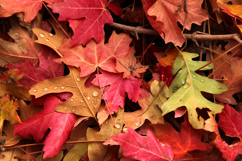
05-NOV-2011
Why go to the refrigerator when it's snowing?
As much as I wanted to stay out of Zion Canyon during the weekends, I decided that the thick clouds made it wise to stay out of the east side washes today. Last night only brought .04", but it looked as though that total was going to rise today.
Since my knees have been doing okay the past few days I decided that I would hike the West Rim trail. My plan was to continue past Scout Lookout. I would keep an eye on the time and decide how far to go. As I started ascending the trail it soon became apparent that my knees weren't in agreement with my plan. I took as many rest breaks as I needed and continued to hike at a glacial pace. By this time my goal had changed to just making it up to Refrigerator Canyon.
Oh did I mention that it's the weekend? Scores of people blew past me. I would say that they left me in their dust, but unlike some days the wind wasn't blowing sand in my face. Or if that was sand, it was the type that's awful light, white, and melts. No, I don't think that's possible either. It must have been snow.
I finally made it to Refrigerator Canyon, which was quite a relief because the trail pretty much levels off in that area. As I had expected there were lots of colorful maples present. I reached the bottom of Walter's Wiggles (a series of short, very steep switchbacks) and paused to consider if I should venture further. I still had a lot of daylight hours left. Maybe I could take it slow. The possibility that taxing my knees any more might make it impossible for me to hike in the coming days was a big factor in my turning around at that point. I'm pretty sure that the trail isn't going away any time soon, so I can always try again in some future year. Well I suppose that rockslides are a possibility, so it might actually be closed at some point, although that doesn't seem like a high probability.
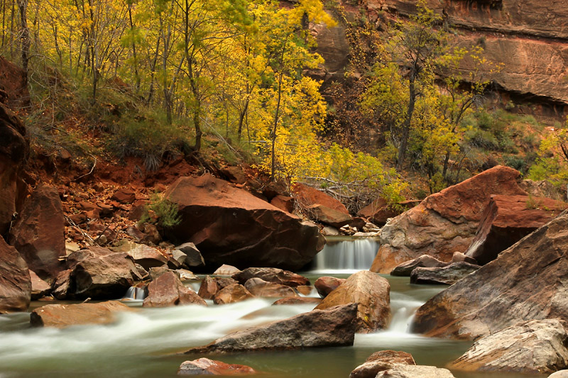
I finished up the day shooting at the Temple of Sinewava and walking the nice, level Riverside Walk trail. My knees felt okay walking on level ground.
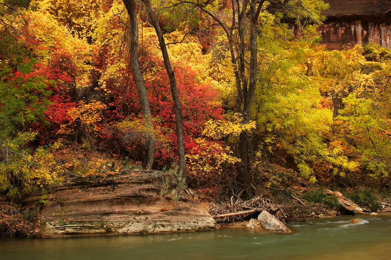
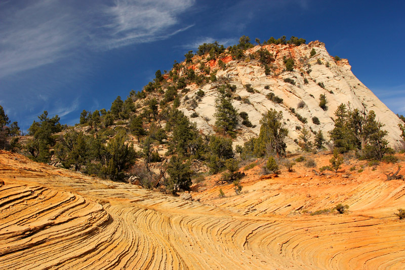
Today's picture is something that feels more like home than the previous photos in this gallery. By home I mean Oregon, not the place where I actually live. It's nice to be shooting water again.
04-NOV-2011
Looking the wrong way
This is not the view I scrambled up the slickrock for. I considered a photo of the view looking down from the saddle at the left side of the picture. That direction is looking down toward a valley and the crack that is the top of Keyhole Canyon. It would have been a good illustration of the drainage showing that to be in a slot canyon during a storm is death. But I sort of liked this picture better.
The forecast of rain today was slightly wrong. The skies were clear almost all day so I was able to get to some places that I thought were going to be off limits. The clouds didn't blow in until almost 4 o'clock. The forecast is now for rain and snow. I'm pretty sure that the forecast is for a weekend as well, which I'm assuming means more people.
While I was out today I though that the title was going to be, "The impending weekend brings crowds." I did not see anyone while I was in Hidden Gardens or Clear Creek. I was just heading back in the West Root Canal when I saw my first fellow hiker of the day. Hey I know that guy. I've seen him in the breakfast room at the motel. He has a bad back, but he hiked to Observation Point (8 miles with 2,000' gain) and Hidden Canyon yesterday. Today he hiked the East Temple Loop. That's too gonzo for me. I sort of like not having to worry about falling to my death if I should happen to slip.
When I was almost back to the road I saw a guy who told me he heard that there was a nesting pair of California condors back, "in the yellow cliffs." I headed up that way but saw that I would have to drop down into the Many Pools drainage to continue. I plan to hike in that area on a future day.
And finally, I saw a couple when I was almost down the slickrock slope below where I took this picture. They told me that they plan to do the Keyhole Canyon route next year so they were just checking things out. So as you can imagine it was quite a crowd in the back country today.
With tomorrow's impending inclement weather, I expect to stay out of the east side drainages. That means that I'll likely be in the crowded main canyon. I was planning to stay out of the canyon during the weekends. Perhaps if it's raining or snowing a great deal of the other people will stay away. Maybe I will too. I haven't even turned on the television in my room yet. I was going to watch The Weather Channel today, but it's not shown on the listing. So much for watching the weather instead of going out into it.
03-NOV-2011
Solitude in a National Park
Today I saw only one other person while I was hiking. That gentleman happened to be a minute away from the road. Yesterday I only saw two other people during my hike. Of course there's a reason why the crowded areas are crowded. Easy access and maintained trails are one factor. Another is that those places happen to be crowded because they're very scenic. I have nothing against them. Of course I usually visit those very places. But there's something very nice about spending a day in the park and feeling as though I have it to myself.
I spent the day in Gifford Canyon and Upper Pine Creek. I finished by trekking through the section of Clear Creek just past the flooded slot where I turned around yesterday. I continued up to the flooded section just upstream from Gifford Canyon. I had planned on catching the afternoon light in the eastern area, but hazy clouds had moved in by that time. There didn't seem to be much point in trying to catch bad light.
Rain is in the forecast for tomorrow. Depending on when it arrives and how much there is, that could present some interesting opportunities. It also means and end to hiking in washes and canyons that are subject to flash floods. I saw tree trunks lodged fifteen feet above the floor of some slots.
Oh and that solitude thing? Don't expect any when you're waiting for sunrise at this location.