19-JUN-2013
Don’t Dam the Sky
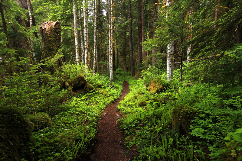
On our last day, we did not go to a highlight kind of hike. I once saw a snapshot that was taken on the Pamelia Lake trail in Oregon. It wasn’t anything special. It wasn’t a great composition. It didn’t have any particular subject. It didn’t indicate why that trail is so popular that hikers need to apply for a limited amount of permits. The thing I loved so much about that picture is that it was simply a representation of a Pacific Northwest forest.
Today we were treated to scattered showers. That’s exactly how the forest should be experienced. We hiked part of the Elliot Creek Trail and a little bit of Monte Cristo. For a change, I didn’t have a difficult time choosing my picture of the day. Instead of my usual creek, waterfall, or wildflower shots, I wanted this one to be a picture of the forest. It’s not any particular interesting scene. It isn’t even a good composition. It’s simply a reminder of being in the forest.
I sometimes wonder if people who live up here appreciate how lucky they are to be in such a beautiful place. I imagine it’s easy to take for granted what you’ve been around your entire life. Looking at it from an outsider’s view, I see an embarrassment of riches. Last week we were driving down US 2 and saw a sign stating Don’t Dam the Sky. It took me a minute to realize what the message was. I remembered that there was a proposal to dam the Skykomish River somewhere around Sunset Falls. There are so many beautiful rivers around here. What if they weren’t so lucky? If the Skykomish was the only river wouldn’t they be ashamed to ruin it? I’ve seen many examples where I marvel at how things have been desecrated. On the good side, there are still so many wonderful places left. I feel as though we’ve only started to explore what this wonderful area has to offer. Obviously we need to return again and again.
18-JUN-2013
Haven’t I been here before?
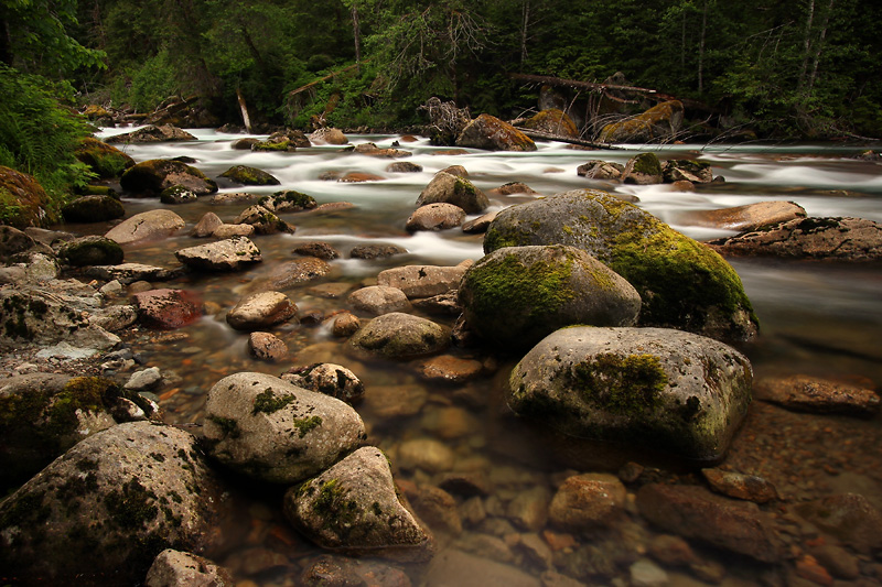
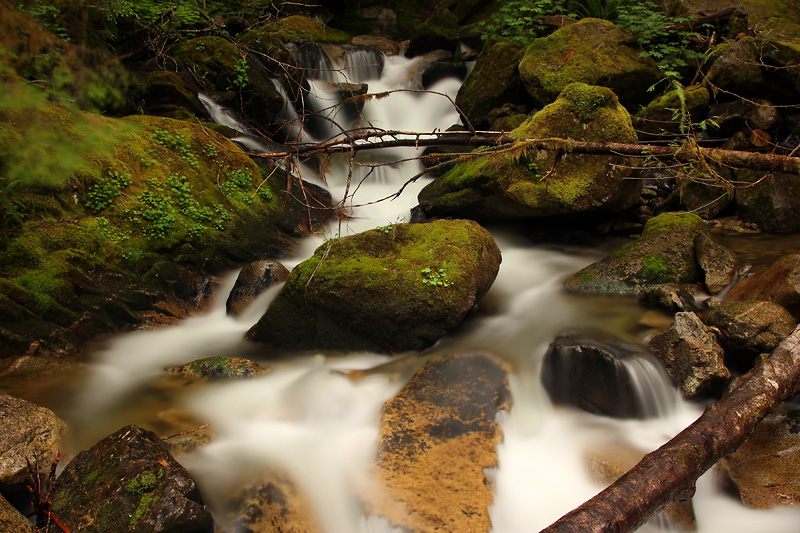
What do you do after spending countless hours planning a vacation, along with enough options for two to three vacations? Improvise. Or maybe just return to the same places. I previously mentioned how much we enjoyed the Mountain Loop Highway. Today we returned to photograph the South Fork Sauk River. There are numerous places with river access. The scenery is simply fantastic. Present are all of the ingredients for my favorite kind of water scenes. There are interesting boulders and riffles, beautiful color, and…aw heck, it’s just my kind of place. We spent all day stopping at all of the pullouts along that section of river. There are so many other things we could have done and nothing that I could imagine that I would have enjoyed more.
17-JUN-2013
Playing Tourist
…because that’s what we are.
Our day was sunned out. We drove, walked interpretive trails, had a small picnic by the river, and did some general sightseeing.
16-JUN-2013
Feature Show
I knew that some of the locations in my plans would (or will) be very crowded. I had no idea that the Boulder River Trail was so popular. Maybe part of the problem is that today is Sunday. I have to confess that when I’m on vacation I don’t much care for weekends.
The weather forecast for today was mostly cloudy with tomorrow anticipated being partly cloudy. I wanted to be at this location on a cloudy day, but that wasn’t to be. The portion of the trail we hiked was mostly in the shade of the trees, but the sun was out, so I didn’t even bother to bushwhack down to Boulder Falls. I was fortunate enough to have some short cloudy moments at Feature Show Falls. The waterfall itself is tall and extremely cool to see in person. I didn’t really shoot the whole falls. I just concentrated on the low portion with the river and boulders as my foreground.
We only hiked a little bit farther on the trail. I spoke with someone who was returning. He said that there was another waterfall about the same distance upstream and that the trail continues to be somewhat high above the river. With the sun out, it didn’t make any sense for us to continue today. Our better option was a Sunday drive on the Mountain Loop Highway.
I wasn’t overly impressed with the east side of the loop. It starts out with some views of the Old Sauk River, which I liked, but we were soon in a tunnel of trees. I have absolutely no problem with that, but I figured that it might be nice to be able to see some peaks on a highway with this name.
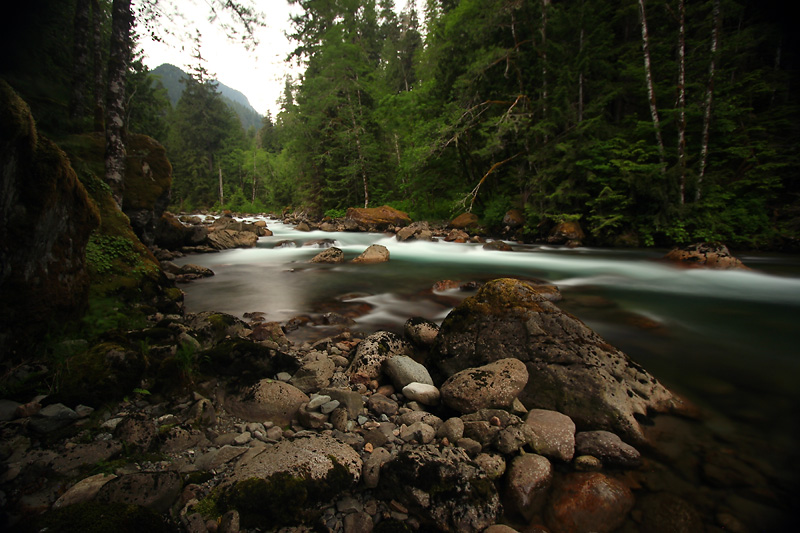
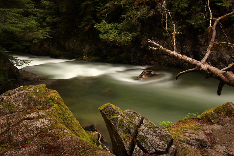
Then my opinion completely changed. There is a portion of the road which has a lot of river access. And what a beautiful stretch it is. The water color is beautiful and there are a lot of rocks to give interest to the scene. We only took advantage of a couple of the spots. By this time of the day the sky had clouded up, which gave me perfect conditions. I set up my tripod and with the ND filter in this light with this scene could absolutely not see anything in either the viewfinder (obviously) or the LCD. Rain was just starting. My only option was to eyeball the camera and point it in what seemed might be a good composition and to focus by guessing my distance. I shot one picture and hurried back to the car. Unfortunately it’s a bit out of focus and heavily vignetted. I still like the photo, so that’s my picture of the day.
Most of the gravel portion of the Mountain Loop is in fantastic shape. The only bad portion is a small area just before the Barlow Pass. Those potholes are deep.
There are some good views of the South Fork Stilly on the south side of the loop. We were only scouting by this time because we decided that we need to either return during this trip or make a point of spending time here during a future year. I’m sure that I could literally plan a whole vacation in just this area.
Tomorrow’s forecast is still partly cloudy. I can only hope that the “bad” weather arrives ahead of schedule. One thing I know is that the weekend is over so those poor working stiffs will be toiling away while we’re enjoying God’s country.
15-JUN-2013
In Leavenworth the man with two alpenhorns is king
Okay so we may not have done the classic Leavenworth tourist thing, but we did have an excellent tour guide today. We learned a lot about the area locations and history.
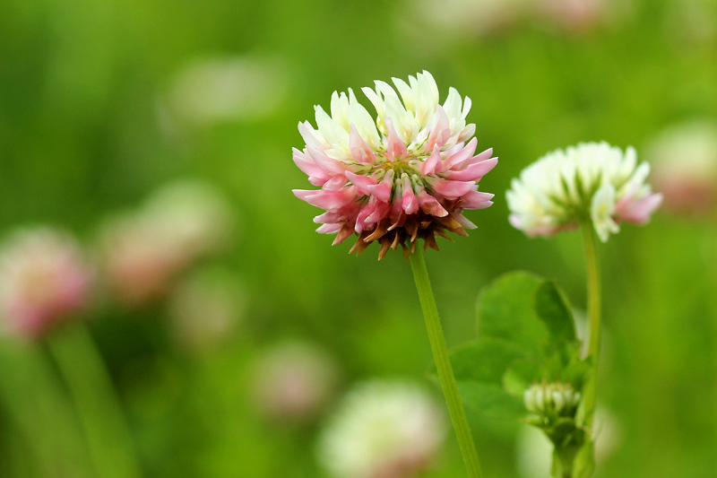
Since the sun was out today was mostly a wildflower day without a lot of wildflowers. We were a bit too late in the areas I had planned. We had short stops at the Tumwater Pipeline Trail, Leavenworth Ski Hill, and Tumwater Botanical Area.
The end of the day was spent driving the Beckler River Road (and an offshoot road) and a road between Index and Gold Bar.
Tune in tomorrow to see if the wonderful clouds return.
14-JUN-2013
Aimless
Well at least we’re not shiftless.
After getting skunked with our search for several waterfalls we stopped at the Iron Goat interpretive site as a turnaround. Instead of just turning around, we decided to just drive down a small section of the Old Cascade Highway that takes off westward from that point. What a nice find. There are views of the river through the trees and several places to stop. One spot is where the bridge spans a creek over a waterfall. There were a few unoccupied primitive camping spots that looked fantastic. This area was a great find. Sometimes it's best to wander around aimlessly exploring.
The Deception Falls parking area was closed, but there was room to park on the highway shoulder. This was probably the best nature trail that we’ve ever seen. Besides being simply wonderful, there were so many places to shoot and running water galore. The only problem was that the sun was toying with me in several spots. In one place, which was the old river channel (that apparently must still run in exceptionally high water) I climbed over slippery, mossy rocks, under logs, and over slippery, muddy rocks. I set up my tripod and the sun came out. After standing there waiting, I gave up and started back. Then I could see the sky through the trees. It was blinding looking towards the sun, but I thought that a cloud might soon bring relief, so I went back and set up the tripod again. And waited. And gave up again. And started to return upon which I decided that the cloud might decide to help me. I repeated this process over and over. Once I made it all the way back the sky darkened. I hurried back and set up only to have the cloud move away before I could shoot. I finally gave up in that location.
There were several other spots where the sun made it impossible to get my shot. But those views were slightly obstructed anyway. I suppose that the important thing was that I got to see those places in person. As far as photography goes, I’m finding it difficult to lament the missed shots since I did get the right conditions in so many of the fantastic spots.
We finished the day with a wonderful visit with Jim and Wendy. It was a fantastic day.
13-JUN-2013
Somebody move that darn tree
The road was horrible, but the trail was lovely. That pretty much sums up our day. The Middle Fork Snoqualmie Trail was on my list of options, but a couple of days ago I knew that it was where we were going to find ourselves today.
So what did I shoot today? Not much of the river, which probably sounds odd since it’s a river trail. The other item you might find odd is that the river isn’t actually in sight for the majority of the portion of the trail we were on. I sometimes have to wonder about trails that are named after rivers or creeks that don’t actually have much water access. But I already knew about it before we arrived. The forest is lush and wonderful, so it was very pleasant walking through it without any particular destination. We shot some wildflowers and ate some salmonberries. I carried my tripod six miles and only shot three pictures with it.
We later ended up walking a small portion of the trail downstream from the bridge (The Pratt River connector). This trail is so sparkly new that they’re still working on it. Carrying my tripod here was a very good thing. I just kept it slung over my shoulder since I had been carrying it all day. It came in very handy where the trail crosses Rainy Creek.
12-JUN-2013
The Wilderness Experience
This was one of those days when I just had to get away from it all – except for traffic noise. The Asahel Curtis Nature Trail is enchanting and loud. Well maybe not completely enchanting, but once again I found that just being in the woods was good enough. The woods might be the safest place since it appears to be outhouse season. I sure hope those idiots check to see that the buildings are vacant before shooting them up. Oh I was supposed to be on topic.
After spending a long time planning the vacation I’m finding that the destination is less important than simply being in the woods. I don’t suppose that will come as a surprise to anyone. Throw in some trees and a creek and I’m a happy boy.
We cut into the Franklin Falls trail at the midpoint. The trail parallels the river, and although the view is mostly obstructed the gorge is beautiful. I only shot three pictures at the falls. It was good to see, but I didn’t feel any great compulsion to do much shooting. The trail is pretty short, so it was a very easy decision to walk downstream and cover the portion we missed instead of returning to the car.
The Denny Creek Trail passes under a high Interstate 90 bridge, so I was serenaded with the comforting sound of traffic – for at least a little bit of the time. The rest of the time I had to deal with the sounds of nature. There were finally plentiful trillium blossoms and blooming skunk cabbage. The bridge is out at the 1.3 mile mark, and I had no intention of soaking my boots and pants. Speaking of water, I’m pleased to report that we’ve had some mighty fine weather. Sure the sun was out at times, but it’s been overwhelmingly overcast. There have been really light showers on occasion. It’s just enough to enjoy the ideal of rain without having to pare down my photo gear to what little will fit under my jacket. Life doesn’t get much better than this.
11-JUN-2013
Goodbye f/22
My recent splurge purchase was a six stop neutral density filter. I had wanted to get a stronger ND for quite some time now. Actually I wanted to get a Singh Ray Vari ND, but one of those is quite a bit more expensive. Of course it would be infinitely easier to use and more versatile as well. But I’m not going to focus on what I don’t have. What I do have is a tool that’s going to open up a lot of possibilities. One of my goals was to get my average water shots shifted from f/22 to a more reasonable aperture – something in the ballpark of f/11 or so depending on the situation of course. The other opportunity is that I can now achieve much longer exposures. That will make it possible to shoot scenes that I couldn’t previously achieve. This is going to be fun.
I got the filter shortly before the trip and didn’t even experiment with it. Actually I haven’t even done any shooting in a while. I suppose I should have played with the filter a little bit at home, but I figured it would work out just fine once I got up here. Well I wasn’t exactly sure how difficult it would be to see and meter through such dark glass, but really what’s the worst that could happen?
We spent time at Olallie State Park. I was shocked to see a credit card accepting state parks pass machine at the trailhead. I decided to purchase an annual pass for $30. I don’t even know how many state parks we’ll be visiting during this trip, but how could I pass up such a bargain? Last I heard the California state parks pass was $120, and that was several years ago.
As you know, I’m a waterfall aficionado, and we saw some nice ones today. I didn’t really didn’t get any good pictures of any that we saw, although I did enjoy them quite a bit. What I did do was shoot the river. And how nice that was using the six stop filter. I’m going to really love that piece of dark glass. And the South Fork Snoqualmie? I happen to think that it’s really nice in that area. It has a lot of character and in many location is a perfect subject for long exposures.
I had a lot of options for the rest of the day, but sometimes it’s better to just enjoy the moment. We strolled along a trail with occasional water access. I didn’t take many pictures, but I have to say that I could not imagine enjoying the afternoon more.
10-JUN-2013
You can’t get there from here
Or maybe you can. But you’re going to have to drive though some doggone hot territory on the way. The high temperature in California on our way north was 114 degrees. A thermometer display on a building claimed that the temperature at the time was 122 degrees, but I feel that it was obviously wrong. Although I’m not exactly an expert on triple degree temperatures, so all I’ll say is that it wasn’t paradise.
In other travel news, we parked on the freeway for over an hour and a half near Cottage Grove, Oregon. On the bright side, I think that the surroundings were much nicer than what I would experience if the freeway were to be closed back home. Then in Portland, thank goodness that they posted an announcement of an accident on an electronic billboard. It was an, “Oh not again!” moment, but on the very bright side we were able to detour so we only had to go about five miles out of our way.
But we’re in Washington, so nothing else really matters. It turned out to be a bit of a warmup day. We started out with a short walk from our motel to Yashiro Japanese Garden. No one is going to mistake this for the Portland Japanese Garden, but still it was nice to have a little park so close by.
I can imagine what the falls at Tumwater used to look like. Since the Olympia Brewery closed the area has been taken over by someone else. I wish I could report who is taking care of the area, but to tell you the truth I didn’t pay any attention. No matter. The damage has already been done. Well I suppose that the fish ladders aren’t considered to be damage, but they detract from the scenic quality of the waterfalls. However, this is still a nice little park.
We hiked part of the Cougar Mountain area. Redtown Meadow is considerably smaller than I had expected. Most of the walk was actually shaded. It was raining caterpillars. I wonder what kind of butterflies they will become. It must be spectacular if they all make it to adulthood. We skipped going to Coal Creek Falls since Coal Creek was hardly flowing. Actually farther downstream the creek bed was dry.
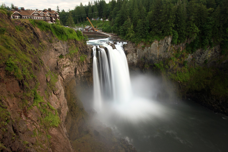
Snoqualmie Falls park has changed quite a bit since the last time we were there. Puget Sound Energy has been busy beautifying the upper viewing areas with new platforms, landscaping, park space, and assorted other amenities. It looks quite a bit different from our previous visit. The important detail is that there is much more room to set up a tripod and not be a hog. There was a lot more water in the river this time, although not as much as I’ve seen in some photographs.
I went looking for another waterfall in the vicinity, but did not see a good vantage, so I didn’t end up taking any pictures. Actually I didn’t even take my camera since I was just scouting.
I didn’t get many pictures or certainly not many keepers today. Tomorrow we’ll start looking at some other places, and maybe I’ll do a little better. Of course that’s relative since it was pretty darn nice spending the day up here.