09-OCT-2015
You are in our hearts always
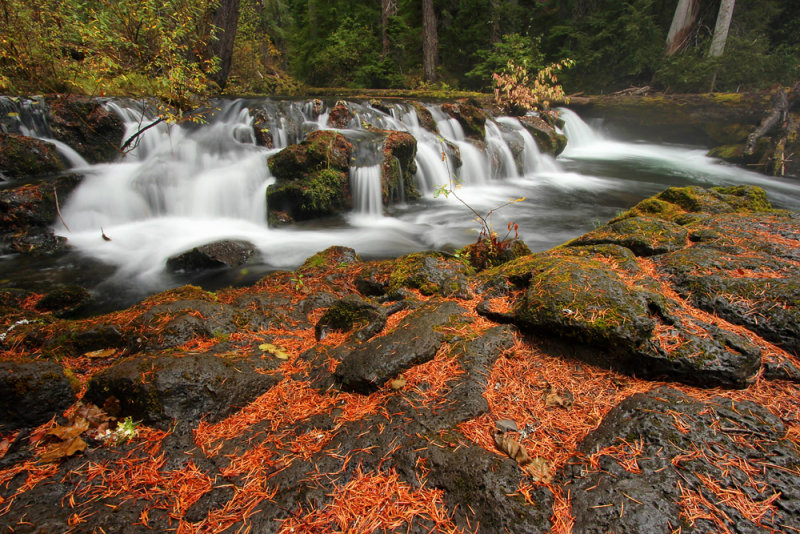
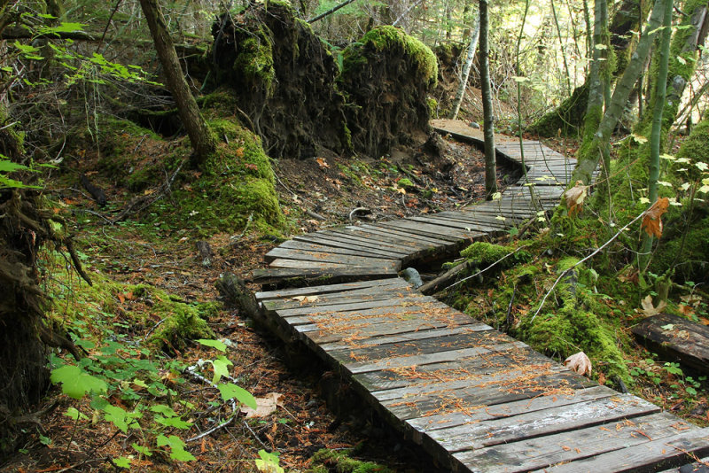
I stopped by Lithia Park in Ashland on my way south this morning. I have a specific spot that I like at a specific time. The trouble is that the sky was overcast. Normally that is exactly what I want for creek and forest pictures. But in this case I need sunlight because it reflects off the foliage into the water. Today’s overcast didn’t much matter since there was almost no color whatsoever.
My report is that this was a terrible year for fall color in Oregon. I did see some, but for the most part the color just wasn’t there. That wasn’t entirely unexpected after the dry summer and warm fall. I figured that it wouldn’t be a good year, but what was I supposed to do? Just skip the vacation? No. But even without much color I did enjoy being there. I visited some favorite places and explored quite a few new locations. I won’t return to some of those places, but I’m glad that I did get to see them.
As for weather, there were way too many sunny days for my liking. I can’t complain though. The sun usually hurts my photography, but I have to admit that it’s very nice hiking without rain gear.
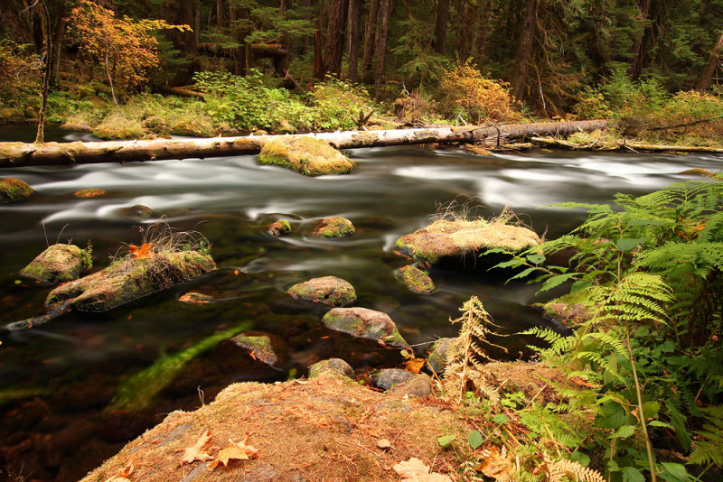
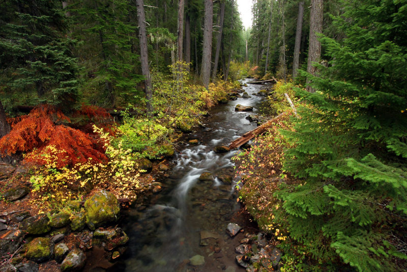
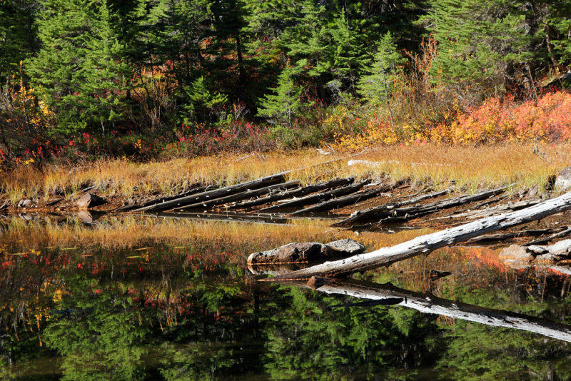
I’ll finish the blog with a shot from the always gorgeous McKenzie River north of Trail Bridge Reservoir.
I stopped to pick up a piece of litter when I was hiking around Daly Lake. It was a cloth ribbon with, “You are in our hearts always” written on it. I put it in a pocket intending on throwing it away later, but I decided to keep it. I’m not sure why.
22-OCT-2015
Eleven herbs and spices
I really struggled this morning while choosing today’s destination. Even though it’s a difficult hike, and even though I didn’t think that I would get any great pictures, I was so very tempted to go hike to the Seven Lakes Basin. If I had one extra day in the area, that’s what I would have chosen. But instead I opted to explore the “River within a River” segment of the Rogue Trail from Hershberger Road to Foster Creek. I did not expect that this would be one of the better parts of the Rogue Trail, but I did want to see it. As a matter of fact, given more time, I would definitely hike much farther upstream from that segment of the Rogue Trail where I know that the river is too gentle to be the type of photographic subject I prefer. Today’s hike didn’t make the cut last time I was here. I only had it among my many optional hikes when I planned this trip. But a ranger told me that it was her favorite section of the Rogue Trail. Having seen the other wonderful segments of the Rogue River Trail, that is very high praise indeed. See, it’s good to ask questions and get firsthand knowledge.
Since I wasn’t going to be driving as long, I found myself in the unusual position of needing to wait a little while before hitting the road. I wanted to take a short hike near Natural Bridge to get a particular shot before driving to my day’s trail, and I needed to wait until there was at least a little light. Maybe it was unfortunate that there was enough light for me to see. While driving on state route 62, I happened to spot a car parked on the side of the road. The elk hunter appeared to be chambering a cartridge while standing right next to the highway, but I’ll give him the benefit of the doubt and assume that he was checking to see that his rifle was not loaded. Safety First!
I know that hiking from the upper trail head requires a ford of Foster Creek. Since I have no way to shuttle hike, I always have to hike out and back instead of one way, which is why it made sense for me to park at Hershberger Road at the south end and hike upstream. Then I could simply turn around at Foster Creek without needing to ford it. It seemed like a good plan to me. The Falcon hiking guide stated, “If you don’t see a sign for the trail, just start walking north along the river.” Well that didn’t last long since there are a few social paths at the start which quickly peter away. There is no trail. So I climbed to Hershberger Road and started walking north while looking for the trail. After a half mile it was obvious that either I’m blind or there is no trail.
That meant that I needed to drive to the north trail head. The Falcon guide’s recommended northern trail head is very bad. I scouted it the other day. It’s an unmarked, and hard to see unless you’re really looking for it, side spur road (and I use that term very loosely) that occurs right after a downhill blind curve on a state highway. What I noticed while previously driving by at 45 MPH is that there might be a hump, and there’s definitely a steep slope. There is, however, an actual, official trail head a half mile north of there. I parked at the safe trail head and headed south. It probably should go without saying that the Falcon hiking guide’s trail mileage was wrong again. The author lists the one-way distance as 4 miles, when in reality it’s 6.5 miles. They’re off by 2 miles (one-way) when accounting for the fact that the real trail head is a half mile north of theirs.
I started hiking, and when I reached Falcon’s trail head, I saw that there were holes and ruts in the dirt right at the top of the slope adjacent to the road. It would not have been possible for me to park there. And even if I could have, it’s not overly safe trying to pull out when a vehicle could come flying around that downhill curve.
It was fortunate that Foster Creek was running low enough that I was able to rock hop across. It was a cold morning and I was not looking forward to immersing my feet in a cold stream.
I have to report that I didn’t particularly care for the trail, and apparently neither does the forest service. I found myself getting ready to flick a branch off the trail, which is not unusual for me. It’s always a good thing when each hiker does some spontaneous trail maintenance as they go along. But in this case the irony that I was going to do so after climbing over yet another downed log. I forced myself to stop. If they don’t care about the trail, then neither will I. Since I wasn’t really taking any pictures, and the scenery wasn’t doing much for me, I did not end up hiking the entire length.
I finished up the day by finishing the end of the River Bridge to Prospect segment that I didn’t complete earlier this week. Thank God I didn’t finish it on that day because I didn’t have rain gear, and my camera gear would have spent a couple of hours getting soaked. Today, however, was a sunny, dry day. I was only planning to hike the part of the trail that is somewhat close to the river. Well, actually the first ľ mile or so is narrow, still, green water at the inlet side of a small diversion reservoir. I reached the area where I had planned to turn around, but I found that somehow I was still going forward. I decided to hike to my previous turn around point in order to complete this trail segment. Although the forest wasn’t as excellent as some others I can think of, this is my last day here so I wanted to spend a little more time in the woods.
I finished the day meandering around the hotel grounds and sitting on patio furniture and on the chairs on the wonderful porch. While I was sitting and reading on the porch swing, some Chinese tourists wanted to have their picture taken with me. Their interpreter said that they liked my mustache and goatee. They must have thought that I was Colonel Sanders.
21-OCT-2015
An island in the sky
I started my drive in the pitch dark this morning. Soon I ended up pulling off the side of the road just so that I could get out and look at the stars.
I saw Mount McLaughlin close up for the first time. Usually it’s just a distant peak seen while driving up Interstate 5. It probably would have looked more impressive if there had been snow on the peak.
I was pleased to see that there were no campers and RVs parked at the Blue Lake Basin trail head. I can’t remember if I previously mentioned this, but it seems that they can set up camp wherever they want around here.
There was frost on the ground in the morning. I enjoyed walking on the crunchy dirt and seeing millions of sparkles.
The trail quickly reached Round Lake, and then Blue Lake. The trail then passes between Blue Lake and Meadow Lake heading toward Horseshoe Lake. I planned to take the short spur to Pear Lake and have a snack, but I seemed to have missed it. I was thinking that I should have reached the lake by then, but I didn’t notice any spur trail. A few feet later I could spot a lake through the trees. I sort of have a habit of bushwhacking shortly before side boot paths, so this time I continued on the main trail, but it was obvious that I had gone too far. Oh well, I figured that I could catch it on the way back.
I wasn’t sure how far I was going to go. I knew that all of the lakes I previously mentioned should make for an easy day, but I had the option of continuing to Island Lake, which is what I decided to do. When I could finally see it, I cut through some trees to a view of the lake. The hiking book mentioned only one unmarked fork to, “the only grassy bank along the shore of large, brush-rimmed Island Lake.” Well the bushwhack I took led me to a very large grassy area, which would normally be large shallow part of the lake. Back to the main trail, I found the unmarked spur. It looked as though it has been abandoned since there are downed logs all over the place.
It was nice to have Island Lake all to myself, although it may not have been worth the effort to get to there. I’m not claiming that it was difficult. It’s just that a shorter day hiking to the other lakes I previously saw is a pretty reasonable option. My plan was to do just that and see how the day was going. I was expecting that might be as far as I would hike today, and I would only end up at Island Lake if I was feeling ambitious.
I could have continued on to the Red Lake trail, which on the map looks like it would come to the shoreline of another part of the lake, but I was almost halfway through the time I had allotted myself for this hike. I knew that I probably did have enough time, but I decided to head back anyway. The sweetener was that if I was making good time, I could hike to yet another lake.
On my way back, I was thinking to myself, I should be near Pear Lake now. I couldn’t see anything, but then it looked like the trees might indicate a possible lake below. Soon thereafter, I spotted a mark that I had left in the trail earlier. Then I could spot the lake through the trees. I bushwhacked, but soon found the actual spur trail.
Pear Lake was a marvelous spot for my snack. It was beautiful, not unlike the rest of the lakes in the area, and I was content to sit there and enjoy the scenery for a while. Then I worked my way down the shore through semi-dry mud and a multitude of rocks and logs lining the water. On my way back I figured that it would probably be easier to take off my boots and just walk through the shallow water. But instead I climbed through the bushes and soon found a use path that took me back to the spur. Do I have any pictures to show you how wonderful the lake looked? No, since I was looking straight into the sun and the pictures wouldn’t have turned out well. It’s too bad that I didn’t spot the side trail in the morning when the light would have been better.
I was making good time. Once I reached the junction, I oriented my map and saw that I would be looking straight into the sun if I hiked to Beal Lake, so I skipped that option. I ended up getting back to the trail head sooner than expected. Tomorrow I have the option of another hike to a bunch of lakes also in the Sky Lakes Wilderness, but that one involves more elevation gain than today’s hike, which had more than enough. Actually it wasn’t really that bad, but if I decide to hike the Seven Lakes trail it would be a lot of work just to get to the first of them.
I was pleased that I was able to hike farther than I had anticipated. That won’t impress you, but sometimes when I get something in my head I like to complete it just because it’s there. Stretch goals is a term sometimes used in business, and elsewhere as far as I know. The other day at a trail head someone asked me if this was what I do for a living. First I told him my job. Then I backtracked and agreed that this is exactly what I do for a living.
20-OCT-2015
Preparations for departure
Yesterday’s attempt to hike the Knob Falls segment of the Rogue Trail got rained out, so I hiked it this morning. I really do like the eastern end of that trail. I love where green moss covers chunks of lava and logs. Towards the end of the outbound part of the hike I was hurrying to get to one particular spot before the sun came out. It turned out that this year there isn’t enough water to make the spot photogenic. I was counting on that spot to save me in terms of providing a shot that I could upload. It’s a struggle on some days.
I learned something today. (As if I didn’t already know it.) No matter how pretty a place is, sometimes I’m never going to get a satisfactory picture of it. Maybe part of that is the experience of being there, which isn’t going to show up in a picture. Because when the composition doesn’t work, it doesn’t matter how pretty the scene is. Today’s picture is a good example. There is some color and reflections, but that’s it.
I didn’t shoot many shots on my way back. But with the sun out, there was a good reflection in the river in one place. I hesitated to set up the tripod since there were distracting branches in the way. But I did it anyway. As I was shooting my first exposure I noticed a big wasp nest about eight to ten feet away from me. I took the time to shoot one more picture after that. You have to realize that isn’t a particularly fast endeavor for me. Then I quietly collapsed the tripod, choked the carrying strap around the legs, and slung it over my neck and shoulder. Next I picked up my trekking poles and put my wrists through the straps. Once I had made my preparations for departure I finally adjusted the camera settings and shot a couple of quick pictures of the nest. I let the camera auto focus and could see that it had selected some leaves in front of the nest, but that didn’t matter. It was only a reference shot.
Yesterday’s weather forecast was off, and I hoped that today’s would be incorrect as well. If that had been the case my second hike would have been the trail segment from Natural Bridge to Rogue Gorge. But since the sun was out I decided to drive to Crater Lake instead. The last time I visited Crater Lake there was just enough snow for them to close the rim drive. This time there was no snow, so I was able to drive all the way around that great big blue lake. Let me tell you, it was easy. Tomorrow I expect to hike to Blue Lake, which will take more effort in order to see a much smaller lake. I have no idea what it looks like, so maybe tomorrow you’ll be seeing commentary without a picture. Or maybe the lake is fantastic. You never know what you’ll find when you hike a new trail.
19-OCT-2015
Biscuits and gravy have a nice day
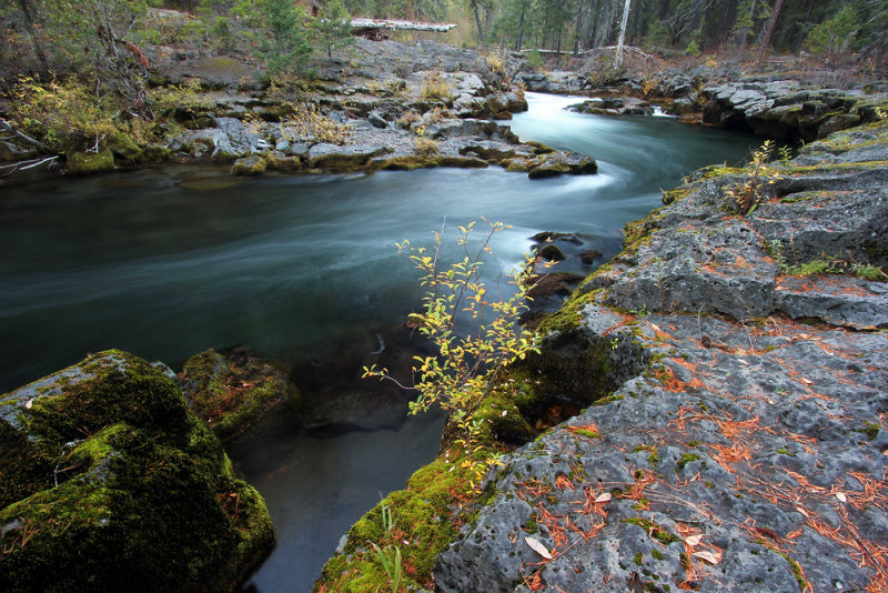
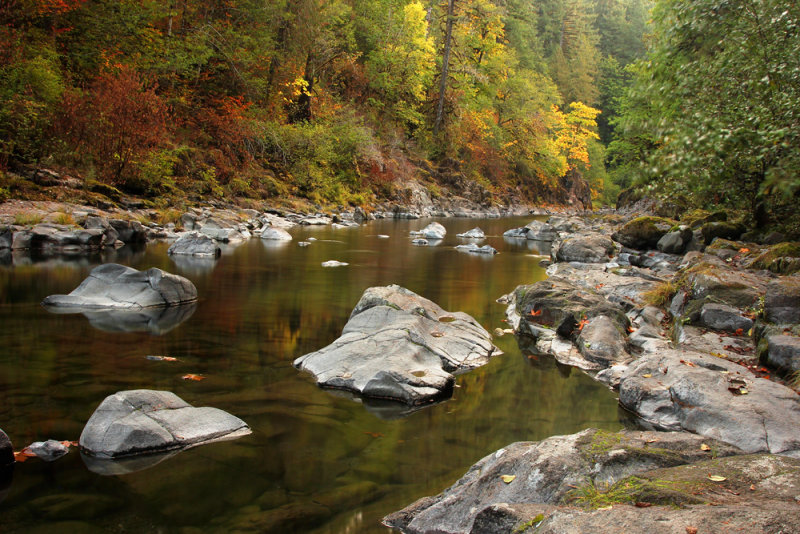
Today’s choice of trails was along the Rogue River from River Bridge to Prospect. I did not expect this segment to be as scenic as some others, which is why it didn’t make the cut last time I was here.
According to the Falcon hiking book, the trail leaves the river to skirt around private property after around three miles. Once again that book is wrong. It lists the segment distance as 4.5 miles when it should be 5.7 miles (each way). When it rejoins the river the water should be calm and placid where it heads into a small reservoir. I’m usually looking for a little more action in my river shots, although placid can sometimes be very nice if there are reflections or other points of interest in the composition. In any case, I chose to head back to the trail head after hiking a little over four miles. That choice would allow me time to hike another segment of the river trail. And it would be easy to catch up on the placid section on a different day. At least that was the plan.
I would say that the first two miles of the trail (heading downstream from River Bridge) were the most scenic. The rest had pretty much no river access, although you can see it down below through the trees at times. Now the very beginning of the trail showed great promise. I first saw it and thought that there would be so many good shots available. However, every spot I checked out had something I didn’t like. Nothing would work out, at least the way that I see things. Maybe another photographer can get fantastic shots there. But my eyes didn’t see any. The picture I will be uploading was from that area. I really wanted to get some ripples in the lava in the foreground. The problem was that would have filled over half the frame with the rest of the fairly uninteresting lava. Today’s picture already has a foreground and composition that isn’t really up to snuff. The ripples were behind and to the left of this spot, so you can imagine how bad it would have looked if I had included them. I know what you’re thinking. Yes, a couple of days ago I did upload a picture that was all foreground. And that foreground was lava. But in that case the effect was exactly what I wanted. I must be fickle, right?
I finished my first hike of the day by noon. The forecast was for a few showers at 3 PM. It was listed as a 35% chance. In reality, there were showers by 12:15. That put to rest any indecision about whether I was going to need to bring rain gear. Very soon after I started hiking the showers became full rain. I continued for just a little while before seeking shelter under a tree that was not yet saturated to the point of dripping. I figured that following my plan and hiking seven miles in this rain was going to result in soaked camera gear. I wasn’t up for a repeat of my soaked Union Creek hike three years ago.
In case you’re wondering about biscuits and gravy, I saw that sign in the window of a gas station convenience mart the other day. With a sign like that, how can anything possibly go wrong?
18-OCT-2015
First world problems
I had very high hopes for today’s hike. I was expecting the South Fork Rogue River to be very scenic. I drove southeast on Road 37. The beginning was single lane paved. Then it switched to gravel, which I actually preferred since it was wider and that lessened the chance that an oncoming vehicle would drive too fast around a blind turn and ruin my day. There were a lot of hunters out this morning. I arrived at the middle trail head and found that, just like most other clearings, it was full of campers. Luckily there was one spot left. I felt sort of like an interloper parking next to someone’s fire ring next to their camper. But in reality it’s a trailhead and not a campground.
The trail was fairly close to the river for a while. I did bushwhack down to the shoreline several times, but didn’t really see any interesting compositions. For the most part the river was shallow and mostly placid with lots of cobbles in the bed and shore. There was only one spot where I got a couple of decent shots.
A wasp stung my finger early in the morning. I’m not lightning fast, so I imagine that the only reason I was able to smash the wasp is because it was intent on pumping as much poison as possible into my finger. Luckily there weren’t any reinforcements. I was a bit surprised to get stung. I know that wasps have a bad reputation, but we usually leave each other alone.
After a while the trail kept turning away from the river and climbing. Every time I looked at my altimeter and thought, “I’m finally by the river, and my elevation is almost as low as the lower trail head” the trail would climb back up away from the river again. I kept hiking for a long time, but decided to turn around before completing the journey to the lower trail head. I just didn’t imagine that the scenery would improve, and I was tired of the elevation gain and loss (and this is heading downstream).
On my way back, I decided to take a spur to the Giant Sugar Pine. The unmarked path climbed to a road. There was a signed trail to the pine on the other side of the road. After going there, I decided to hike back on the road instead of going back on the trail. Not only was the surface better, but this way my legs wouldn’t continue brushing up against all of that vegetation that was wet from yesterday’s rain. On yes, my waterproof pants were soaked and my boots were wet.
Instead of driving back the way I came, I decided to drive on 34 towards Butte Falls. That was a stroke of luck. Almost immediately I crossed a bridge over the South Fork Rogue and looked over the side. The view was exactly what I had hoped I would see during the hike! There were spots to pull out on both sides of the bridge, so I parked and took some pictures. Now I have a dilemma. After the hike downstream I had mentally crossed off the idea of hiking in the upstream direction tomorrow. But after seeing the view from the bridge I have to wonder if the river is prettier in the upstream direction. Probably not. I think it’s part of a plot to make me drive back and spend another day being disappointed. And here’s more information about the devious plot. I got back in my car to continue my drive only to find that the paved road soon had two lanes! It gets better. There was colorful dogwood on the sides of the road. But, like many diabolical conspiracies, the perpetrators were soon done in by their evil nature. The clear cuts ruined the dastardly scheme.
Although the forecast was mostly cloudy, I had full sun all morning. That was not a problem since it wasn’t like I would have gotten good pictures anyway. The clouds came in near the end of my hike, which presented me with an opportunity to visit a few waterfalls very near Prospect.
Yesterday I got a picture that I liked a lot, but I had a few bad spots from rain on my lens. I had been attempting to shield my lens and had been checking, but I missed the droplets at that one particular spot. It was
17-OCT-2015
Man on an island
I had planned to visit Lemolo Falls on my way to Prospect. I decided that it might be best to skip that area due to thunderstorms being in the forecast. There must be something about Lemolo. This is the third time that weather has kept me away. The weather wasn’t exactly pleasant the one time that we were able to go there. It was 102 degrees that day. For the rest of the world, that’s obviously measured in Fahrenheit.
Taking another route did allow me to stop at one picturesque spot on the South Umpqua. This time there was some pretty green algae in the water. That’s probably not great for the folks who surely visit the area in the summer, but I thought it was pretty. I was busy taking pictures and then decided to wash the sand off my tripod feet. I startled a large fish when I put them in the water. It quickly left the shallows, and I lost sight of it in the stirred up algae.
After a long drive, I started a hike on the Rogue River. I quickly decided that I wasn’t going to have time for a seven mile hike. I knew that I was going to be stopping rather soon and spending a lot of time taking pictures at Natural Bridge. I still think that folks behind the fence on the other bank must wonder about the idiot walking on the lava adjacent to the river. But they’re behind a fence, and there is no fence on the side I come in on. It’s also right next to a campground, so I cannot imagine that a lot of people aren’t out there in the same place as me during the summer.
Instead of hiking to the Rogue River Gorge, I drove my car there. I’ve already hiked that area in the past. I would love to do it again, but I probably won’t have time during the rest of the trip. I have too many places to see, and not enough time to revisit trails.
I always look forward to photographing a very scenic area above Rogue River Gorge. Imagine my surprise and disappointment to find that the river channel is currently all but dry. I started walking back to the car but turned around when I realized that this was a rare opportunity to explore the island. I have to report that it was fine to see, but I didn’t see many photographs of the main Rogue channel.
My next stop was at Union Creek Falls. There were a lot of cars and trailers parked along the road to the upper trail head. I noticed that people seemed to be camping wherever they could find a spot. Last time I was here I hiked the Union Creek Trail from the lower trail head. This time it was a quick walk from the upper trail head to the falls.
I finished the day at the always wonderful National Creek Falls. The funny thing is that after taking pictures at a bunch of locations, I almost ended up choosing a quick snapshot for my picture of the day. I was hiking up the switchbacks and saw a little section of the trail I really liked. I thought I might have time to go to another location, so I was hurrying. I don’t suppose that y’all are that interested in a shot of the trail, so I’ll have to choose a different picture. I’m going to do that next, so at the moment I still don’t know what I’m going to share.
I’m back. I decided to choose a picture of Union Creek Falls. I shot the falls from a different perspective last time I was here. I think I may prefer that vantage, but I wanted something different this time, so I chose to emphasize the lava in the foreground. I also think that the photograph itself is better. Although I certainly wouldn’t claim to be a highly skilled photographer, I believe that I’ve gotten better over the past few years. The funny thing is that before this month I hadn’t even held a camera in almost a year. At the beginning of this trip I was stumped trying to remember how to switch on my camera’s live view. I had wondered if I would be getting any decent shots. I needn’t have worried; I’m in my element. There’s nothing I like better than rivers and creeks running through the forest.
16-OCT-2015
Panning for gold
I had quite an easy day. I had nothing to do other than spend my time taking shots along the Little North Santiam and Cedar Creek. That’s in contrast to the folks who were gold panning at Three Pools. I don’t know if they find much, but you’ve got to hold out hope that you’ll be the one who succeeds in finding a big nugget. It seemed like an interesting thing to do. I wouldn’t mind trying it if I lived up here. Of course I expect that most of the time it’s just hard work with little payout. Maybe I would start off panning and then a few hours later realize that I had just been sitting on a rock or log next to the creek absorbing the scenery and daydreaming.
15-OCT-2015
Calculated risk
Yesterday I tried to take a few quick glances at the North Santiam above Detroit Lake. There are pullouts along SR 22, and it looked as though there might possibly be some good pictures down there, although it’s kind of hard to tell at 55 miles per hour. I was tempted to stop and check them out this morning, but I decided that I would be better off sticking to the plan and going to a few waterfalls and Marion Lake (hopefully before the sun was fully on the falls.)
I stopped to see two waterfalls before getting to the Marion Lake trailhead. The second was Gooch Falls, and let me tell you it’s pretty impressive.
There was an inmate work crew building a rail fence when I arrived at the trail head. You can’t beat that, either from their perspective or mine. From theirs, it’s a chance to get outside. From mine, how could me car be any more safe at a trailhead than on a day when there is a sheriff hanging around?
Personally, I didn’t think that the forest was anything close to exceptional. Perhaps I’m spoiled after getting to visit Pamelia yesterday. The forest at Marion pales in comparison. What this hike does have is a waterfall. Oh, and I suppose that most people would prefer this trail since, not only is Marion a much bigger lake, but you also get a bonus lake.
I started scrambling up the hill alongside the Marion Outlet Trail too soon. I stopped a couple of times to take a look behind me so that I would know what to expect on my way out. Then I ran into the real path to Marion Falls. At the beginning the path looks like a real trail, but then it gets fainter. It was always pretty easy to follow. Or maybe I should say it was easy to locate. Following is another story. Once you reach the brink of the falls the fun starts. It’s a steep scramble down to several viewpoints of the upper tier and lower viewpoints of both tiers.
My gamble paid off since I was just early enough to have the right light from two vantages. I didn’t bother to go any farther down because at that point the sun was lighting the next spot I would have shot from. Since I would have been looking right at the sun, and since there was also now a bright spot on the waterfall, I decided not to go through the trouble of scrambling any farther down. Instead I just stood there for a long time watching the water. I ended up looking at one particular spot for quite a while, and when I decided it was time to leave I looked up and the world was moving. Vertigo is not what I needed just in time to scramble back up the hill so I looked at the falls a little while longer.
On my way out I did some trail work. I removed some debris from the path, and I placed some sticks and branches at the edges to help outline the way. I also placed a big stick across the entrance to the side path so that people who intended on taking the Outlet Trail wouldn’t make a wrong turn.
Later in the day I met a couple of ladies who said they were looking for the waterfall. I gave them instructions on how to get there. They asked if I had seen the inmate crew. I mentioned having seen an unsupervised inmate crew in the past. They were surprised, but I figure that the inmates would have to be supremely stupid to mess up a good thing like that. Escaping would mean not only a longer sentence, but serving the entire thing behind walls. Besides, as I mentioned to the women, I’m paying a lot of money for the opportunity to be out in the woods.
Soon after I started my return from the lake I started to smell smoke. Camp fires are banned in the area, and there hasn’t been any lightning, so I wasn’t sure where it was coming from. As I hiked back downhill the smoke intensified. I stopped at the Detroit Ranger Station to ask if there was a controlled burn. The lady told me that there was one in the McKenzie district.
14-OCT-2015
That’s not permitted here
Yesterday morning I went online and purchased my Pamelia Lake permit. There are a limited amount of permits available, but I suppose that if all twenty day use permit holders bring the maximum number of people you’re looking at a crowd of 160 people. It looks like there is also a single permit for a group of 9-12 people. I think that the overnight permits are subtracted from the day use allotment. In any case, at this time of year it’s not bad. I saw that six other permits were reserved for today, but I only saw three people.
Pamelia Lake was really small. The water level was as low as I’ve ever seen it. Of course you can take that with a grain of salt since my sample size is two visits. However, due to the conditions this year I feel confident that the water level is much lower than normal. And a big for instance would be looking at you from over the tree line. Mount Jefferson is looking mighty bald. I only saw two small patches of ice. That surprised me since I was pretty sure that I saw more when I was looking at the north face from the Olallie Lake area a couple of days ago. I was looking directly into the sun at the time.
Although I knew I wasn’t going to have time to hike to Hunt’s Cove, I was expecting to hike a lot farther than I did last time. Ha Ha (Clinton Dix). That last part was unnecessary, but since I was typing “Ha Ha”, my mind naturally completed the rest. Just in case you don’t know, that’s the name of an NFL safety. But back to your regularly scheduled programming. The laughter is because it’s quite obvious that there was no way that I was going to be able to hike through the lovely forest next to a creek without stopping to enjoy the scenery as well as spend a whole lot of time taking pictures.
13-OCT-2015
Where’s that confounded gorge?
I didn’t have high hopes for the South Breitenbush Gorge hike. My main reason for going there is because the drive along forest road 46 is pretty. It’s part of the West Cascades National Scenic Byway. I wanted to get off the road and this seemed like as good a spot as any.
It turns out that this is one of those river trails that has almost no river access and hardly offers even limited views through of the water through the trees. It was a pleasant enough trail through the forest as long as you’re not expecting to reach some specific destination. Although in this case there is, in fact, a specific destination. My hiking guide described a sign for the gorge and a path to the right of the trail. I was feeling kind of stupid for missing those things by the time I reached Roaring Creek. But that’s okay. I was going to continue a way on the trail and then I could search more carefully on my way back. By the way, the view from the trail bridge over roaring creek is a very nice cascade through mossy rocks. It would have been very photogenic if patches of sun had not been on it.
On my way back I once again knew that I was in the gorge area. I could hear the water below. For the second time I went down a hill to a bit of a clearing, but I don’t think that I was going to attempt to scramble down any farther than that. Besides, where is this side trail described in the book? Once I was obviously past the gorge area for the second time I decided that the author’s pleasant lunch spot was not likely to be visited by many of his readers.
It’s kind of sad that my upload was the best picture I could get. That was right near the start. There were also some unique and interesting bridges in that area.
So to summarize my day:
I didn’t find the gorge.
It was too sunny for the kinds of forest shots I like.
I didn’t get access to the river shore, but that didn’t matter because of the sun.
I enjoyed the day.
This list is probably grammatically incorrect, but I don’t care because I didn’t have to go to school today.
12-OCT-2015
Lost
Maybe the title should have been Trail on Fire. I got my fall color fix with red huckleberry leaves. The area was definitely past peak. The majority of the leaves had fallen. But there was still plenty of color to be found.
No, I didn’t get lost. I know where my limitations lie. Last week I was trying to find a couple of lakes without trails. I climbed up on a ridge and couldn’t see them. I could have continued bushwhacking, but I wasn’t sure that I was going to both find the lakes and find my way back to the trail, so I stopped my search.
Today I was in the Land of Small Trees. That kind of LoST. Olallie Lake is over twice as high as Opal Creek, which was where I was yesterday. Being in the higher elevation forest with small trees was quite a change from the Opal Creek old growth. Another change was that I only saw one other hiker all day. Olallie Lake itself was deserted. Amazingly, there weren’t even any helicopters in the sky. It was like it was the end of the world and the last two people left had nothing better to do than hike to a bunch of small lakes.
11-OCT-2015
The Un-Opal Opal
I’m not too happy with ODOT. It’s bad enough that they closed Interstate 5, but why couldn’t they close the entrance to the ramps instead of letting cars drive on the ramp and get stuck. All they would have needed to do is park the truck with the freeway closed sign a hundred yards back. Then I could have taken an alternate route. There, I got that out of my system.
Since it had rained yesterday, I stopped at Salmon Falls Park to change into waterproof boots and put on gaiters. When I pulled into the parking area, I noticed a new kiosk with bright orange life jackets hanging off the front. It’s the Blayk Austin Memorial Life Jacket Loaner Station. It’s never a good thing when something like that is named after you.
I had forgotten just how bad the gravel road heading to Opal Creek is. It’s certainly passable with any car, but the going is slow. As soon as I got to that part of the drive a light clicked on in my head, and I thought, “Oh yeah, I remember how slow this road is.”
Well first of all, I was surprised to find myself going to Opal Creek at all. I had planned to visit on a week day since it’s a popular place and I don’t like crowds. The reason I switched locations for today is because this was supposed to be the only partly cloudy day this week, and I wanted to take advantage of that.
As expected, there were plenty of people enjoying Opal Creek, but it wasn’t that bad. Well there was that one persistent border collie who wanted to play fetch with a stick that he found. I was talking to his owners for quite some time. They told me not to throw the stick or I would have to keep it up all day long.
I wanted to check out the 2013 realignment of the Mike Kopetski trail upstream from Opal Pool. A couple of guys were standing at the trailhead when I arrived. On said that I wasn’t going to see anyone else on the trail. It was pretty rough – mostly roots, rocks, trees to climb over, steep sections, etc. At one point I stopped to take some pictures and noticed that my lens pouch was soaking wet from brushing up against all of the vegetation encroaching on the trail. I was thinking about maybe turning around, but I decided to keep going. Later I had to climb up on a slippery fallen log in order to climb over another log. I slipped and was unable to catch my balance until I landed on my butt. Then my balance was perfect! It was at that point that I decided I wasn’t going to reach Cedar Flat. On my way back I was surprised that I did, in fact, see two other people on the trail. The women asked me if that was the way back to the parking lot. Someone had told them that was the way to go. Luckily they hadn’t yet traveled very far. I gave them the correct directions, including information that once they cross the bridge near Opal Pool there it was a bit confusing with all of the social trails. That turned out to be outdated info. The Forest Service has put up signs and tried to block off the social paths.
I didn’t end up taking many pictures today. The weather forecast was wrong. It was sunny and pleasant all day. A good day to hike, but not a good day for the sort of pictures I like to shoot. And to tell you the truth, Opal Creek just didn’t have that wonderful color today.
10-OCT-2015
It was hard to believe
Yes, it was hard to believe that high winds and heavy rain were in the forecast. I arrived at the Wizard Falls Fish Hatchery right at 8 (when they’re open for visitors). I don’t suppose it would have mattered if I got there a bit earlier, since I was just going to park there and hike along the Metolius River. There was bright sun the last time I was at the Metolius, and you know how much I hate that when I’m hiking along a river. This time I was early enough to be able to shoot the rapid by the vehicle bridge before the sun was high enough in the sky to put it’s evil light on the scene. In case you’re wondering, the sun rose above the hills at 8:55. I was setting up my tripod and camera for a shot and the scene literally lit up across the scene like someone panning a light as I was preparing my shot. It was like watching a time lapse video, except that it happened in about a minute.
As I was hiking along in some areas I felt that it was a lot like being in Laguna at home, except for that river thing down below. Farther along, the trail travels pretty much right alongside the river. You have to love trails that do that. And since that area is a small canyon, the direct sun was not yet intruding into the scene.
I had forgotten how fast the Metolius moves in the canyon area. In case you’re wondering how much that is, the flow, measured in cubic feet per second, is “pretty darn fast”. I put that in quotes because I made it up. But I’m fairly sure that it’s the correct measurement.
There wasn’t anyone else when I was at the springs. I sat on a rock and ate my snack while looking at the springs gushing out of the hill right next to the river. It was nice. Cheryl would have liked sitting there enjoying the moment.
By this time it was getting windy. High winds were supposed to precede the rain, so I headed back. I did stop at the hatchery to feed the fish in the settling pond. I thought the little pellets smelled like cat food. Maybe I should have picked up a big bag of cat food from Costco. That would have set off a feeding frenzy. There was no soap in the restroom, and my hands smelled like cat food during the entire drive back to town.
There was very good fall color near the turnoff for Echo Basin and Hackleman Old Growth trail. I should have stopped for a quick hike (at Hackleman, not Echo Basin), but I’m paranoid about leaving my car full of all of my luggage unattended. That was the reason I picked the Metolius River as my location today. I’m my mind, it just seems a little safer than some other places.
My timing was good. It was still sunny when I left Wizard, and although it was very windy and some clouds had finally shown up, it was still sunny enough that you wouldn’t believe it was going to rain. As I drove west there were light showers as I approached Sweet Home. They stopped when I arrived at the hotel. It rained hard a short while after I checked in. Now it’s stopped, and that should be it for the rain for the next week.
09-OCT-2015
Tranquility, with helicopter
I drove to a different area today. The road, off the eastern section State Route 22, is signed for Old Cascade Crest Trails. I’m very pleased to report that the color in that area is very fine indeed. Just driving on SR 22 was a treat.
I hiked to four lakes in that area. All were worth seeing at least once. I don’t know that I would return. It’s not that the lakes weren’t enjoyable. The trouble is that there’s a lot to see in a limited amount of time, so I doubt that they would make the cut for a future trip. But I got to enjoy them today. For the most part I enjoyed the solitude. Why if it were not for the ever present sound of a helicopter I might have even thought I was enjoying nature. I’m not kidding. That helicopter was flying around for the entire time I was out in that area. I never saw it, but I sure heard it.
I finished the day at Tamolitch Pool. I’ve been there four times. The most recent had been in 2012. Something has changed. I had seen signs highlighting Blue Pool among the can’t miss local attractions. Now there are signs and a large parking area. There are also lots of people. I used to have the place to myself, but now there are probably as many people as I’ve seen on a fall week day at Silver Falls State Park. I probably wouldn’t have seen so many people if I had stuck to the original plan and went there first thing in the morning. But due to the weather forecast I switched and saw the lakes while it was sunny and then went to Tamolitch when the clouds came in. That worked out very well. That part of the McKenzie is very attractive, and in my opinion photographs exceptionally well.
08-OCT-2015
Lunch Break
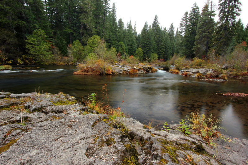
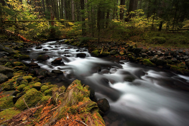
My objective today was to explore the East Fork South Fork McKenzie River. I didn’t have a whole lot of information about it. I did know that it would be twelve to thirteen miles with no less than 1750’ gain. That’s just calculating the starting and ending elevations without taking the ups and downs along the trail into consideration. What I didn’t know is how many ferns, salal, and other vegetation are intruding onto the trail. Walking through that got tedious really fast.
The good part is that the river, which looked like a creek to me, reminded me a lot of French Pete Creek. I love to see water tumbling though rocks. Like most creek trails, the trail doesn’t actually have a whole lot of creek access. Oh, there’s probably enough, but not as much as anyone in their right mind would prefer. The picture is from my lunch spot. A lot of the time when you get down to the creek, you’re just looking for a place to set up a tripod with a decent composition. Often that’s easier said than done. However, in that spot there was not only plenty of room for pictures, but even rocks perfectly placed for seating.
At some point I realized that not only was I not loving wading through vegetation in the trail, but my slow speed was going to make it difficult to finish before it got really late. If they ever brush out the trail I would consider returning to complete the entire distance, but for today I decided to turn around short of my goal. I was filthy by the time I returned to my car. Not only had all of that vegetation rubbed dirt onto my belt pack, backpack, camera, tripod, and clothes, but I discovered that I even had dirt and needles in my pockets.
Truncating my hike allowed me to finish my day at French Pete Creek. The scenery is similar to East Fork South Fork, but the trail sure was in better shape. I guess that’s what you get at a much more popular trail.
07-OCT-2015
Home is where the art is
I took full advantage of the mostly overcast day and hiked a section of the McKenzie River Trail that I had never before seen. I spent the day between Trail Bridge Reservoir and Frissell Boat launch. I have to say that the section between Trail Bridge and Deer Creek was fantastic. Not only was it beautiful, but I saw much more red vine maple than I would have expected given that most of the fall vine maple I see is usually yellow. It’s always a treat to see the red leaves. If the fall color and the scenic river were not enough, I was really loving the forest. At one point I came to the conclusion that I was home. I even scratched a picture of a house in the dirt with one of my trekking poles. Note – I did see it again on my way back down the trail. The artwork left something to be desired, but the feeling was authentic.
Since I loved that hike so much, and since I was feeling okay, I was pleased to continue my hike south of Deer Creek. What a difference. While the trail is fine, I felt that it paled in comparison to what I had seen in the morning. I hardly took any pictures. I just didn’t see many opportunities. Not to mention that in some areas you’re looking right across the river at SR 126.
All this time I had been wondering when I was going to start encountering mountain bikers. The McKenzie River trail is very popular in the mountain biking community. I kept thinking that was the day wore on they would have rode their way down from the upper trailhead to where I was at. I was very surprised that I only saw two bikers while I was hiking. I did see three more as soon as I finished my hike.
There are only three other parts of the McKenzie River Trail I have yet to hike. I’m pretty sure that I’ve seen the best of it. But I haven’t been from the start along Fish Lake Creek to Clear Lake. That’s always dry when I visit. The section from Carmen to Tamolitch is always dry (the water is diverted from Carmen to Smith Reservoir). And I have yet to hike from Frissell to Paradise. I may try to fit in that section in a couple of days, but I’ll more likely be going to Tamolitch, which I’ve already seen several times. Of course Tamolitch Pool is spectacular in its own right, but I’m also hoping to see a lot more red vine maple.
Today was a very successful day. I had very little trouble with my knee and was able to hike almost 13 ˝ miles. Tomorrow I’ll be feeling even better. Oh, and after talking about red vine maple, I seem to have chosen a shot showing vine maple that is not red with a helping of reddish dogwood. If it’s any consolation, that tiny patch of red across the river is vine maple.
06-OCT-2015
The Fourth and a half crossing
One day at Mount Rainier we were on the Fourth Crossing trail. It’s just a quarter mile connector from an overflow lot to the main Paradise trails. The trouble is that it’s incredibly scenic with Paradise Creek running down through rocks and wildflowers. Once we reached the top, I looked at my watch and asked Cheryl if she had any idea how long it took us to hike a quarter mile. I can’t remember the exact time, but it was incredibly long – something like an hour and a half or maybe longer. That’s what happens when you lose track of time while surrounded by incredible beauty.
I’m certainly no expert on American rivers. I’m sure that there are many that are exceptionally scenic. But I do have to think that if one was to make a list of the most beautiful half mile stretches of rivers the McKenzie between Sahalie and Koosah would have to be in the running. Although I’ve been there many times, I still found myself taking over two hours to walk that down and back up that short stretch of trail.
The rest of my day was spent at Clear Lake. About half way around I stopped at a bench to eat my lunch. After I finished I just sat there for a lot longer. The color of the leaves and lake were beautiful and I felt at peace. There was nowhere else I wanted to be.
I finished my hike early in the afternoon. I certainly had time to spend seeing something else, but my knee was finished hiking several miles before I was. The good news is that it’s doing better than yesterday and I’ve decided that I’ll be good to go for the rest of the trip.
05-OCT-2015
I forget, therefore I am
I think about a lot of things while I’m hiking. Sometimes I think about the things I plan to write about in the blog. Unfortunately I sometimes forget what those items are when it’s time to actually start writing.
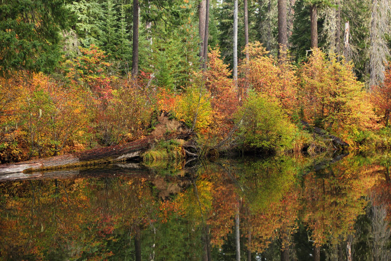
After the unusual weather in the Pacific Northwest the past year I had no idea how fall color would be turn out. It’s always a gamble, but I was a bit pessimistic this year. As I started the drive up state route 242, I saw that the vine maple, which I could have expected to be yellow, wasn’t particularly colorful. It’s hard to hit peak color in different areas during a several week trip. Usually I arrive later to catch better color elsewhere in the following weeks. But I planned an earlier vacation especially to catch the best color at Proxy Falls and Clear Lake. Proxy did have some red leaves, but they weren’t especially vivid. Not having good color there seemed to be a bad sign for things to come. Another observation is that with the dry year, Proxy Falls was flowing as low as I’ve ever seen. There was no water flowing over the interesting moss-covered columnar basalt on the left side. Upper Falls was flowing about normal, although it’s difficult to get pictures since there are too many trees in the way. Once again I was amazed at how much water flows into the pool without an outlet. How can that much water disappear into the ground?
I don’t know how this fits into the equation, but the huckleberry bushes were bright crimson on the Benson Lake/Tenas Lakes hike. So it was nice to see blazing color even if it may not continue with other plants in other locations I’ll be visiting.
I was doing pretty good, and doing a lot of bushwhacking. Then almost as soon as I was back on the trail returning from Tenas Lakes my knee started to hurt. It wasn’t a lot of fun limping all the way back to the car. Useful strategies are pivoting on the other leg like a peg-legged pirate or leaning way forward on trekking poles so that you can bend your ankle forward and confine the movement to the hip above the bad knee. You would be surprised at how you can walk without moving a knee when the trail is reasonably flat.
Earlier in the day I visited White Branch Falls. For the last four days I had tried to call to ask permission to enter their camp. I had assumed that they were closed for the season. But, since the gate was open when I arrived, I figured that I would drive to the camp and look for someone. That wasn’t necessary since a woman was walking a dog while enjoying her morning coffee. She was very nice. And in case you’re wondering, the golden retriever’s name is Daisy.
Other quick stops were Hand Lake, which, unbeknownst to me, is actually a meadow at this time of year. I also went to Craig Lake and the McKenzie Pass. So I saw lot of scenery, although I’m not very good at taking pictures of lakes. I plan to go to Clear Lake tomorrow and see if the vine maple is red. While I’m hiking I’ll make sure to think about lots of interesting things, which I will forget before I get back to the room.