


|
|
|
|
|
|
|
| |
| 22-JUN-2006 | Dave Beedon |
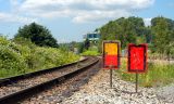
This looks northeast from C. P. Tukwila toward Black River Junction. The two signs have
something to do with permission to proceed (thanks, Monte!). Note the indentation at
the top of each sign from its having been pounded into the railway ballast.
The track at left is owned by Union Pacific (UP). The two tracks behind the
signs are owned by Burlington Northern Santa Fe. Up until 1980, the UP track
was also used by The Milwaukee Road per a trackage agreement.
The building on the hill in the distance is an office building called Millenium
Centre, also pictured here: http://www.pbase.com/listorama/image/55763996 .
Up ahead, where the tracks meet, the view to the north looks
like this: http://www.pbase.com/listorama/image/62893631 .
Out of view to the left is a scenery-spoiling amusement park.
"Control point" (C. P.) is defined here: http://en.wikipedia.org/wiki/Rail_terminology .
.
All images are copyright 1966 - 2023 by Dave Beedon (davebeedon AT comcast DOT net).
ERROR: 500
NOTES: [hset] LOADING Redis is loading the dataset in memory, at /usr/local/share/perl5/Redis.pm line 268. ,
PBASE_ENV: production
Try Again:Go Home