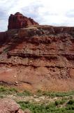
I photographed this north slope of the Goose Neck in 2004 in anticipation of scrambling up it to reach the mesa on top. With the aid of binoculars, I determined that this slope would almost certainly support an ascent by "scrambling" (no need for technical climbing equipment such as a rope).
My 2005 trip to Moab included a plan to explore this slope, but it was one aspect of the trip that had to be canceled because one of my boots came apart. But in 2006 I got revenge for that disappointment by scrambling up to the mesa, although I went up the slope at far left, which was easier. The only easy access to the slope is via the river. I paid for a boat ride to the Goose Neck and back.
This photo was taken from San Juan County Route 142, a rugged dirt road that runs from Potash to Canyonlands National Park. The western end of 142 follows the route of the old Shafer Trail.
|