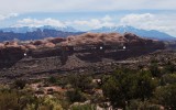
The dots mark terrain features I examined up close two days after taking this picture. The left and middle dots are just below the extremities of a tilted plateau (my primary goal) and the right dot marks the location of a garden I examined during the same visit. The tilted plateau is at the center of this Wikimapia aerial view. Geotagging is approximate.
This was shot from the Amasa Back Trail and looks eastward at (from front to rear):
1. Kane Springs Canyon
2. a bench about half-way up the image on which runs the Hunter Canyon Rim Trail (plateau's access route)
3. a gently-tilted plateau (just above the left and middle dots)
4. a garden area next to the plateau and behind the right dot
5. bulbous fins on the plateau
6. dark landscape of Behind the Rocks, and
7. the snowy La Sal Mountains.
When I first hiked on the Amasa Back Trail (two years earlier) the tilted plateau called to me to be explored. Two days after taking this picture I answered that call by hiking 5.5 miles from Kane Creek Road to the tilted plateau and the nearby garden mentioned above. About half that distance was on the Hunter Canyon Rim Trail; the remainder was off-trail travel: navigation was aided by Google Earth print-outs. The off-trail section included an easy scramble among ledges that led up the the plateau of fins. Navigating among the fins was fun.
The hike was about eleven miles round trip. At its end I was a tired puppy.