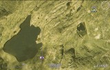
The large body of water is lac du Brévent (Lake Brévent), in the mountains west of Chamonix, France. I posted this Google Earth view to show Flickr member choofly where she was when she took a picture, as she could not remember. Choofly's vantage point was about at the center of this WikiMapia aerial view (where the camera icon is above) and she was looking west-northwest.
The camera icon and white line in the image represent choofly's vantage point and view axis of her photograph (the image is on Flickr).
Choofly thought her picture might have been taken at lac Cornu, but Google Earth revealed that the shoreline of lac Cornu did not match the one in her picture. In addition, the terrain just didn't look like the terrain I photographed at lac Cornu in 1973 (part of a Tour du Mont Blanc; gotta scan those slides!). That turned on my "solve this geographic puzzle" light, which led to my examining lac du Brévent.
I found her photo when searching for images of nearby lac Cornu, a place where I had camped in 1973. That was the fourth night in a 17-day circumnavigation of the Mont Blanc massif. My backpacking adventure was a variation of the Tour du Mont Blanc.
At upper right is a tent symbol representing the approximate location of my campsite in August 1973, the day after I camped at lac Cornu.
Colors of the tent and camera icons are faded because of my brightening of the dark green Google Earth image.
|