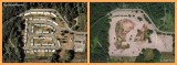
These Google Earth views show the condition of the Capehart Housing area at Fort Lawton in Seattle, Washington. The views are from 2002 (Google Earth historical imagery) and 2012.
Fort Lawton is a former U.S. Army base in Seattle. The Capehart Housing area was, I believe, housing for non-commissioned officers and their families. The last vestiges of the fort closed in 2011. Most or all of its property is now part of Seattle's Discovery Park. Most buildings have been razed so the land can be returned to a natural state.
Apart from the general interest in the way things change, this is important to me because I spent a lot of time in Fort Lawton in the mid-1960s when I was a civilian teenager living nearby. (Although there were guards at each of the three gates of the fort, civilians could come and go almost at will and two city bus lines passed through the fort every day.) I remember the one-story duplexes of this housing area.
The housing area is at the center of this WikiMapia aerial view.
Another website has photos of the demolition and restoration.
Side-by-side image made with PhotoScape.
|