photo sharing and upload picture albums photo forums search pictures popular photos photography help login
Dave Beedon | all galleries >> Places >> Utah >> Moab (environs) >> Tombstone Plateau > Backside of The Tombstone
previous | next
12-MAY-2014

Backside of The Tombstone

view map


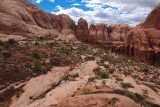
The cliff at left is part of a sandstone fin called "The Tombstone." Its far side, straight ahead and visible in other photos in this gallery, is a sheer cliff standing above Kane Creek Road. From the canyon containing the road, the face of the fin resembles the shape of a tombstone.

In this view to the west, Pritchett Canyon is the dark area at right. I was on a shelf about 100 feet (30 m) above the bottom of the canyon.

Nikon D80
1/400s f/14.0 at 18.0mm iso400 full exif

other sizes: small medium large original auto
share
Type your message and click Add Comment
It is best to login or register first but you may post as a guest.
Enter an optional name and contact email address. Name
Name Email
help private comment