photo sharing and upload picture albums photo forums search pictures popular photos photography help login
Dave Beedon | all galleries >> Places >> Utah >> Blue Castle Canyon > The Green River
previous | next
18-OCT-2008 20081018_3043

The Green River

view map


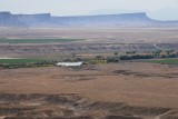
Looking east-southeast from the summit block of Blue Castle. The Green River is flowing from left to right (toward the city of Green River). At top: the La Sal Mountains, barely visible in the haze, about 50 miles (80km) away. In from of the La Sals is the gently-sloping Hatch Mesa. The dirt road at bottom is the route I drove to get here. Pivot irrigation is practiced here.

Nikon D80
1/320s f/18.0 at 112.0mm iso200 hide exif
Full EXIF Info
Date/Time18-Oct-2008 12:18:31
MakeNikon
ModelNIKON D80
Flash UsedNo
Focal Length112 mm
Exposure Time1/323 sec
Aperturef/18
ISO Equivalent200
Exposure Bias-1 2/3
White Balance
Metering Mode
JPEG Quality
Exposure Program
Focus Distance9999.000 m

other sizes: small medium large original auto
share
Type your message and click Add Comment
It is best to login or register first but you may post as a guest.
Enter an optional name and contact email address. Name
Name Email
help private comment