Location: north of Castle Gate, Utah and next to US 6 and the Price River.
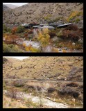
The upper photo, from October 2007, shows derailed hoppers lying on the slope next to the Price River. The tracks had been cleared so trains could pass. I noticed the hoppers while driving up US 6 and quickly pulled over to the very wide shoulder and parked for photos. The lower photo is the same scene in April 2012.
Finding this location for a return visit was a challenge because the only record of the location was my remembering that it was in the canyon north of Castle Gate, possibly at the apex of a curve. This realization took place when I was adding placemarks to Google Earth and could not determine where to place one for this derailment photo.
Not knowing the location was frustrating so I decided to look for the site during my Spring 2012 trip to Utah. I saved Google Earth images of the four locations that I thought could be the site and took them with me when driving to Moab. My intention was to check those four sites as I drove south on US 6. As it turned out, the first site I visited was the site of the derailment. I felt good about solving this geographic riddle.
20071005_9969 and 20120426_4347
20071005_9969 and 20120426_4347
|